Norma geodata
Norma (Latium) is a seat of a third-order administrative division; located in Italy in Europe/Rome (GMT+2) time zone. With population of 3,473 people, there are 2700 cities with bigger population in this country. Compared to other cities in Italy, 74.1% of cities are located further ↑North; 67.9% of cities are located further ←West and 74.1% of cities have lower elevation than Norma. Note1


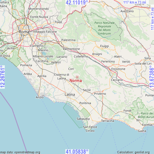
Norma GPS coordinates[2]
41° 35' 11.148" North, 12° 58' 14.628" East
| Map corner | latitude | longitude |
|---|---|---|
| Upper-left | 42.11019°, | 12.26761° |
| Center: | 41.58643°, | 12.97073° |
| Lower-right: | 41.05838°, | 13.67386° |
| Map W x H: | 117×116.9 km | = 72.7×72.6mi |
| max Lat: | 47.04031° ⇑74.1% North |
| Norma: | 41.58643° |
| min Lat: | ⇓25.9% South 35.50142° |
| min Long | Norma | max Long |
| 6.69888° | 12.97073° | 18.48682° |
| W 67.9%⇐ | ⇒32.1% E |
Elevation
Elevation of Norma is 440 m = 1444 ft, and this is 133.3 m = 437 ft above average elevation for this country.
| Max E: |
2085 m = 6841 ft | 25.9% |
| Norma | 440 m 1444 ft | |
| Avg. | 306.7 m = 1006 ft | |
Min E: |
-4 m = -13 ft | 74.1% |
See also: Italy elevation on elevation.city.
Geographical zone
Norma is located in North temperate zone (between Tropic of Cancer and the Arctic Circle). Distance of this Northern Tropic circle is 2018.1 km =1254 mi to South.| Distance of | km | miles | from Norma |
|---|---|---|---|
| North Pole | 5383.1 | 3344.9 | to North |
| Arctic Circle | 2777.2 | 1725.7 | to North |
| Tropic Cancer | 2018.1 | 1254 | to South |
| Equator | 4624 | 2873.2 | to South |


Nearby cities:
15 places around Norma: (largest is in red/bold)
• Bassiano
6.1 km =3.8 mi,  129°
129°
• Borgo Carso
8.9 km =5.5 mi,  229°
229°
• Carpineto Romano
9.6 km =6 mi,  77°
77°
• Carrara-Pontenuovo
5.3 km =3.3 mi,  194°
194°
• Chiesuola
11.1 km =6.9 mi,  215°
215°
• Cisterna di Latina
11.9 km =7.4 mi,  272°
272°
• Cori
8.1 km =5 mi,  322°
322°
• Latina Scalo
6.4 km =4 mi,  198°
198°
• Montelanico
9.2 km =5.7 mi,  38°
38°
• Monticchio
5.1 km =3.2 mi,  175°
175°
• Rocca Massima
11.1 km =6.9 mi,  338°
338°
• Segni
12.1 km =7.5 mi,  19°
19°
• Sermoneta
4.3 km =2.7 mi,  164°
164°
• Sezze
12.2 km =7.6 mi,  141°
141°
• Sezze Scalo
11.6 km =7.2 mi,  148°
148°
Sources, notices
• [Note1] Compared only with cities in Italy existing in our database
• [Src1] Map data: © OpenStreetMap contributors (CC-BY-SA)
• [Src2] Other city data from geonames.org with taken over terms of usage.
• [Src3] Geographical zone / Annual Mean Temperature by Robert A. Rohde @ Wikipedia
