Priverno geodata
Priverno (Latium) is a seat of a third-order administrative division; located in Italy in Europe/Rome (GMT+2) time zone. With population of 10,005 people, there are 949 cities with bigger population in this country. Compared to other cities in Italy, 75% of cities are located further ↑North; 70.2% of cities are located further ←West and 70.2% of cities have higher elevation than Priverno. Note1


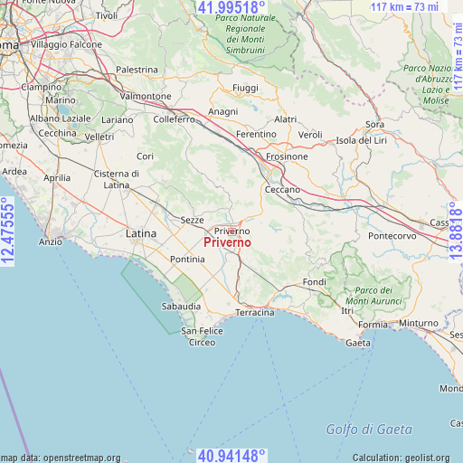
Priverno GPS coordinates[2]
41° 28' 13.692" North, 13° 10' 43.212" East
| Map corner | latitude | longitude |
|---|---|---|
| Upper-left | 41.99518°, | 12.47555° |
| Center: | 41.47047°, | 13.17867° |
| Lower-right: | 40.94148°, | 13.8818° |
| Map W x H: | 117.2×117.2 km | = 72.8×72.8mi |
| max Lat: | 47.04031° ⇑75% North |
| Priverno: | 41.47047° |
| min Lat: | ⇓25% South 35.50142° |
| min Long | Priverno | max Long |
| 6.69888° | 13.17867° | 18.48682° |
| W 70.2%⇐ | ⇒29.8% E |
Elevation
Elevation of Priverno is 96 m = 315 ft, and this is 210.7 m = 691 ft below average elevation for this country.
| Max E: |
2085 m = 6841 ft | 70.2% |
| Avg. | 306.7 m = 1006 ft | |
| Priverno | 96 m = 315 ft | |
Min E: |
-4 m = -13 ft | 29.8% |
See also: Italy elevation on elevation.city.
Geographical zone
Priverno is located in North temperate zone (between Tropic of Cancer and the Arctic Circle). Distance of this Northern Tropic circle is 2005.2 km =1246 mi to South.| Distance of | km | miles | from Priverno |
|---|---|---|---|
| North Pole | 5396 | 3352.9 | to North |
| Arctic Circle | 2790.1 | 1733.7 | to North |
| Tropic Cancer | 2005.2 | 1246 | to South |
| Equator | 4611.1 | 2865.2 | to South |


Nearby cities:
15 places around Priverno: (largest is in red/bold)
• Amaseno
13 km =8.1 mi,  91°
91°
• Borgo Faiti
14.9 km =9.3 mi,  268°
268°
• Giuliano di Roma
11.4 km =7.1 mi,  47°
47°
• La Fiora
15.2 km =9.4 mi,  175°
175°
• Maenza
6 km =3.7 mi,  3°
3°
• Patrica
14.4 km =8.9 mi,  21°
21°
• Pontinia
13.1 km =8.1 mi,  239°
239°
• Prossedi
8.6 km =5.3 mi, 53°
• Roccagorga
6.4 km =4 mi,  342°
342°
• Roccasecca dei Volsci
3 km =1.9 mi,  72°
72°
• Scalo
4.6 km =2.9 mi,  157°
157°
• Sezze
10.3 km =6.4 mi,  288°
288°
• Sezze Scalo
11.7 km =7.3 mi,  284°
284°
• Sonnino
8.2 km =5.1 mi,  136°
136°
• Villa Santo Stefano
12.1 km =7.5 mi,  64°
64°
Sources, notices
• [Note1] Compared only with cities in Italy existing in our database
• [Src1] Map data: © OpenStreetMap contributors (CC-BY-SA)
• [Src2] Other city data from geonames.org with taken over terms of usage.
• [Src3] Geographical zone / Annual Mean Temperature by Robert A. Rohde @ Wikipedia
