Falerone geodata
Falerone (The Marches) is a seat of a third-order administrative division; located in Italy in Europe/Rome (GMT+2) time zone. With population of 500 people, there are 9934 cities with bigger population in this country. Compared to other cities in Italy, 62.5% of cities are located further ↑North; 73.2% of cities are located further ←West and 68.1% of cities have lower elevation than Falerone. Note1


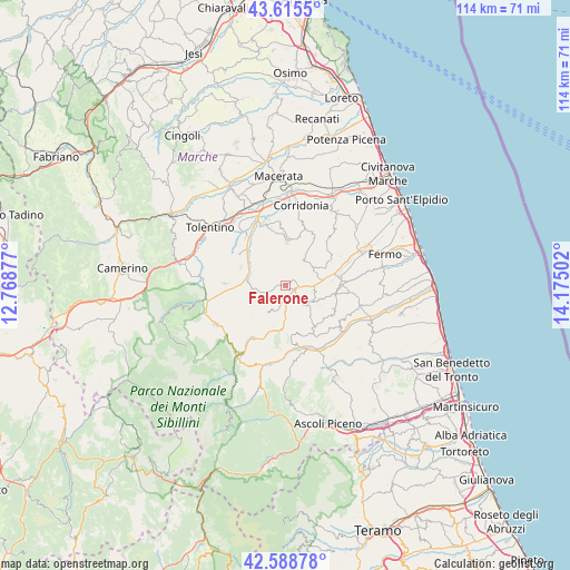
Falerone GPS coordinates[2]
43° 6' 15.444" North, 13° 28' 18.804" East
| Map corner | latitude | longitude |
|---|---|---|
| Upper-left | 43.6155°, | 12.76877° |
| Center: | 43.10429°, | 13.47189° |
| Lower-right: | 42.58878°, | 14.17502° |
| Map W x H: | 114.2×114.2 km | = 71×71mi |
| max Lat: | 47.04031° ⇑62.5% North |
| Falerone: | 43.10429° |
| min Lat: | ⇓37.5% South 35.50142° |
| min Long | Falerone | max Long |
| 6.69888° | 13.47189° | 18.48682° |
| W 73.2%⇐ | ⇒26.8% E |
Elevation
Elevation of Falerone is 374 m = 1227 ft, and this is 67.3 m = 221 ft above average elevation for this country.
| Max E: |
2085 m = 6841 ft | 31.9% |
| Falerone | 374 m 1227 ft | |
| Avg. | 306.7 m = 1006 ft | |
Min E: |
-4 m = -13 ft | 68.1% |
See also: Italy elevation on elevation.city.
Geographical zone
Falerone is located in North temperate zone (between Tropic of Cancer and the Arctic Circle). Distance of this Northern Tropic circle is 2186.8 km =1358.8 mi to South.| Distance of | km | miles | from Falerone |
|---|---|---|---|
| North Pole | 5214.3 | 3240 | to North |
| Arctic Circle | 2608.4 | 1620.8 | to North |
| Tropic Cancer | 2186.8 | 1358.8 | to South |
| Equator | 4792.7 | 2978 | to South |


Nearby cities:
15 places around Falerone: (largest is in red/bold)
• Belmonte Piceno
5.7 km =3.5 mi,  104°
104°
• Loro Piceno
8.3 km =5.2 mi,  323°
323°
• Massa Fermana
4.8 km =3 mi,  3°
3°
• Monsampietro Morico
7.9 km =4.9 mi,  120°
120°
• Montappone
3.6 km =2.2 mi,  356°
356°
• Monte San Martino
8.4 km =5.2 mi,  197°
197°
• Monte Vidon Combatte
8.1 km =5 mi,  192°
192°
• Monte Vidon Corrado
2.3 km =1.4 mi,  37°
37°
• Montegiorgio
6.2 km =3.9 mi,  62°
62°
• Monteleone di Fermo
7.8 km =4.8 mi,  143°
143°
• Penna San Giovanni
6.6 km =4.1 mi,  215°
215°
• Piane
2 km =1.2 mi,  113°
113°
• Piane di Montegiorgio
7.8 km =4.8 mi,  80°
80°
• Sant'Angelo in Pontano
6.1 km =3.8 mi,  263°
263°
• Servigliano
3.2 km =2 mi,  148°
148°
Sources, notices
• [Note1] Compared only with cities in Italy existing in our database
• [Src1] Map data: © OpenStreetMap contributors (CC-BY-SA)
• [Src2] Other city data from geonames.org with taken over terms of usage.
• [Src3] Geographical zone / Annual Mean Temperature by Robert A. Rohde @ Wikipedia
