Montegiorgio geodata
Montegiorgio (The Marches) is a seat of a third-order administrative division; located in Italy in Europe/Rome (GMT+2) time zone. With population of 2,616 people, there are 3396 cities with bigger population in this country. Compared to other cities in Italy, 62.3% of cities are located further ↑North; 74.1% of cities are located further ←West and 67.6% of cities have lower elevation than Montegiorgio. Note1


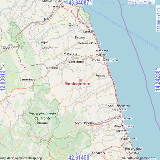
Montegiorgio GPS coordinates[2]
43° 7' 47.568" North, 13° 32' 21.3" East
| Map corner | latitude | longitude |
|---|---|---|
| Upper-left | 43.64087°, | 12.83613° |
| Center: | 43.12988°, | 13.53925° |
| Lower-right: | 42.61458°, | 14.24238° |
| Map W x H: | 114.1×114.1 km | = 70.9×70.9mi |
| max Lat: | 47.04031° ⇑62.3% North |
| Montegiorgio: | 43.12988° |
| min Lat: | ⇓37.7% South 35.50142° |
| min Long | Montegiorgio | max Long |
| 6.69888° | 13.53925° | 18.48682° |
| W 74.1%⇐ | ⇒25.9% E |
Elevation
Elevation of Montegiorgio is 369 m = 1211 ft, and this is 62.3 m = 204 ft above average elevation for this country.
| Max E: |
2085 m = 6841 ft | 32.4% |
| Montegiorgio | 369 m 1211 ft | |
| Avg. | 306.7 m = 1006 ft | |
Min E: |
-4 m = -13 ft | 67.6% |
See also: Italy elevation on elevation.city.
Geographical zone
Montegiorgio is located in North temperate zone (between Tropic of Cancer and the Arctic Circle). Distance of this Northern Tropic circle is 2189.7 km =1360.6 mi to South.| Distance of | km | miles | from Montegiorgio |
|---|---|---|---|
| North Pole | 5211.5 | 3238.3 | to North |
| Arctic Circle | 2605.6 | 1619 | to North |
| Tropic Cancer | 2189.7 | 1360.6 | to South |
| Equator | 4795.6 | 2979.8 | to South |


Nearby cities:
15 places around Montegiorgio: (largest is in red/bold)
• Belmonte Piceno
4.2 km =2.6 mi,  179°
179°
• Capparuccia
7 km =4.3 mi,  89°
89°
• Falerone
6.2 km =3.9 mi,  242°
242°
• Francavilla d'Ete
6.5 km =4 mi,  0°
0°
• Grottazzolina
5.6 km =3.5 mi,  102°
102°
• Magliano di Tenna
4 km =2.5 mi,  77°
77°
• Massa Fermana
5.5 km =3.4 mi,  290°
290°
• Monsampietro Morico
7 km =4.3 mi,  169°
169°
• Montappone
5.7 km =3.5 mi,  277°
277°
• Monte San Pietrangeli
7.3 km =4.5 mi,  24°
24°
• Monte Vidon Corrado
4.2 km =2.6 mi,  256°
256°
• Piane
5.1 km =3.2 mi,  224°
224°
• Piane di Montegiorgio
2.7 km =1.7 mi,  124°
124°
• Rapagnano
5.2 km =3.2 mi,  50°
50°
• Servigliano
6.7 km =4.2 mi,  214°
214°
Sources, notices
• [Note1] Compared only with cities in Italy existing in our database
• [Src1] Map data: © OpenStreetMap contributors (CC-BY-SA)
• [Src2] Other city data from geonames.org with taken over terms of usage.
• [Src3] Geographical zone / Annual Mean Temperature by Robert A. Rohde @ Wikipedia
