Serole geodata
Serole (Piedmont) is a seat of a third-order administrative division; located in Italy in Europe/Rome (GMT+2) time zone. With population of 16 people, there are 11686 cities with bigger population in this country. Compared to other cities in Italy, 51.8% of cities are located further ↓South; 90.5% of cities are located further →East and 84.5% of cities have lower elevation than Serole. Note1


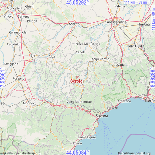
Serole GPS coordinates[2]
44° 33' 14.544" North, 8° 15' 35.064" East
| Map corner | latitude | longitude |
|---|---|---|
| Upper-left | 45.05292°, | 7.55661° |
| Center: | 44.55404°, | 8.25974° |
| Lower-right: | 44.05084°, | 8.96286° |
| Map W x H: | 111.4×111.4 km | = 69.2×69.2mi |
| max Lat: | 47.04031° ⇑48.2% North |
| Serole: | 44.55404° |
| min Lat: | ⇓51.8% South 35.50142° |
| min Long | Serole | max Long |
| 6.69888° | 8.25974° | 18.48682° |
| W 9.5%⇐ | ⇒90.5% E |
Elevation
Elevation of Serole is 601 m = 1972 ft, and this is 294.3 m = 966 ft above average elevation for this country.
| Max E: |
2085 m = 6841 ft | 15.5% |
| Serole | 601 m 1972 ft | |
| Avg. | 306.7 m = 1006 ft | |
Min E: |
-4 m = -13 ft | 84.5% |
See also: Italy elevation on elevation.city.
Geographical zone
Serole is located in North temperate zone (between Tropic of Cancer and the Arctic Circle). Distance of this Northern Tropic circle is 2348 km =1459 mi to South.| Distance of | km | miles | from Serole |
|---|---|---|---|
| North Pole | 5053.1 | 3139.8 | to North |
| Arctic Circle | 2447.2 | 1520.6 | to North |
| Tropic Cancer | 2348 | 1459 | to South |
| Equator | 4953.9 | 3078.2 | to South |


Nearby cities:
15 places around Serole: (largest is in red/bold)
• Bergolo
6.1 km =3.8 mi,  263°
263°
• Cortemilia
6 km =3.7 mi,  299°
299°
• Denice
7.7 km =4.8 mi,  49°
49°
• Levice
8.5 km =5.3 mi, 258°
• Merana
5 km =3.1 mi,  142°
142°
• Molino-Pera
8.3 km =5.2 mi,  151°
151°
• Mombaldone
6.1 km =3.8 mi,  72°
72°
• Olmo Gentile
3.7 km =2.3 mi,  343°
343°
• Perletto
6.2 km =3.9 mi,  323°
323°
• Pezzolo Valle Uzzone
5.5 km =3.4 mi,  251°
251°
• Piana Crixia
8.6 km =5.3 mi, 153°
• Roccaverano
4.4 km =2.7 mi,  13°
13°
• San Giorgio Scarampi
6.5 km =4 mi,  347°
347°
• Spigno Monferrato
6 km =3.7 mi,  101°
101°
• Torre Bormida
8.4 km =5.2 mi,  276°
276°
Sources, notices
• [Note1] Compared only with cities in Italy existing in our database
• [Src1] Map data: © OpenStreetMap contributors (CC-BY-SA)
• [Src2] Other city data from geonames.org with taken over terms of usage.
• [Src3] Geographical zone / Annual Mean Temperature by Robert A. Rohde @ Wikipedia
