Sermide geodata
Sermide (Lombardy) is a seat of a third-order administrative division; located in Italy in Europe/Rome (GMT+2) time zone. With population of 3,599 people, there are 2623 cities with bigger population in this country. Compared to other cities in Italy, 60% of cities are located further ↓South; 53.2% of cities are located further →East and 93.6% of cities have higher elevation than Sermide. Note1
Administrative division(s):
- Level 1: Lombardy
- Level 2: Provincia di Mantova
- Level 3: Sermide e Felonica


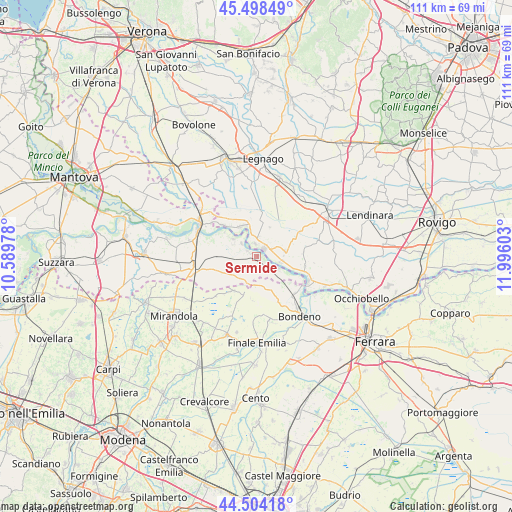
Sermide GPS coordinates[2]
45° 0' 12.564" North, 11° 17' 34.44" East
| Map corner | latitude | longitude |
|---|---|---|
| Upper-left | 45.49849°, | 10.58978° |
| Center: | 45.00349°, | 11.2929° |
| Lower-right: | 44.50418°, | 11.99603° |
| Map W x H: | 110.6×110.6 km | = 68.7×68.7mi |
| max Lat: | 47.04031° ⇑40% North |
| Sermide: | 45.00349° |
| min Lat: | ⇓60% South 35.50142° |
| min Long | Sermide | max Long |
| 6.69888° | 11.2929° | 18.48682° |
| W 46.8%⇐ | ⇒53.2% E |
Elevation
Elevation of Sermide is 11 m = 36 ft, and this is 295.7 m = 970 ft below average elevation for this country.
| Max E: |
2085 m = 6841 ft | 93.6% |
| Avg. | 306.7 m = 1006 ft | |
| Sermide | 11 m = 36 ft | |
Min E: |
-4 m = -13 ft | 6.4% |
See also: Italy elevation on elevation.city.
Geographical zone
Sermide is located in North temperate zone (between Tropic of Cancer and the Arctic Circle). Distance of this North polar circle is 2397.3 km =1489.6 mi to North.| Distance of | km | miles | from Sermide |
|---|---|---|---|
| North Pole | 5003.1 | 3108.8 | to North |
| Arctic Circle | 2397.3 | 1489.6 | to North |
| Tropic Cancer | 2398 | 1490 | to South |
| Equator | 5003.9 | 3109.3 | to South |


Nearby cities:
15 places around Sermide: (largest is in red/bold)
• Bergantino
7.2 km =4.5 mi,  333°
333°
• Borgofranco sul Po
8.1 km =5 mi,  306°
306°
• Calto
5.4 km =3.4 mi,  105°
105°
• Carbonara di Po
6.1 km =3.8 mi, 305°
• Castelmassa
2.4 km =1.5 mi,  46°
46°
• Castelnovo Bariano
2.7 km =1.7 mi,  351°
351°
• Ceneselli
6.1 km =3.8 mi,  79°
79°
• Correggioli
12 km =7.5 mi, 305°
• Felonica
5.5 km =3.4 mi,  119°
119°
• Magnacavallo
8.6 km =5.3 mi,  272°
272°
• Melara
9.9 km =6.2 mi, 313°
• Moglia
2.3 km =1.4 mi,  298°
298°
• Pilastri
6.3 km =3.9 mi,  183°
183°
• Salara
10.7 km =6.6 mi,  100°
100°
• San Martino Spino
9.1 km =5.7 mi,  210°
210°
Sources, notices
• [Note1] Compared only with cities in Italy existing in our database
• [Src1] Map data: © OpenStreetMap contributors (CC-BY-SA)
• [Src2] Other city data from geonames.org with taken over terms of usage.
• [Src3] Geographical zone / Annual Mean Temperature by Robert A. Rohde @ Wikipedia
