Salara geodata
Salara (Veneto) is a seat of a third-order administrative division; located in Italy in Europe/Rome (GMT+2) time zone. With population of 876 people, there are 7285 cities with bigger population in this country. Compared to other cities in Italy, 59.6% of cities are located further ↓South; 51.6% of cities are located further →East and 95.3% of cities have higher elevation than Salara. Note1


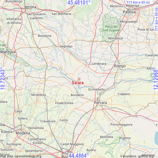
Salara GPS coordinates[2]
44° 59' 9.096" North, 11° 25' 35.58" East
| Map corner | latitude | longitude |
|---|---|---|
| Upper-left | 45.48101°, | 10.72343° |
| Center: | 44.98586°, | 11.42655° |
| Lower-right: | 44.4864°, | 12.12968° |
| Map W x H: | 110.6×110.6 km | = 68.7×68.7mi |
| max Lat: | 47.04031° ⇑40.4% North |
| Salara: | 44.98586° |
| min Lat: | ⇓59.6% South 35.50142° |
| min Long | Salara | max Long |
| 6.69888° | 11.42655° | 18.48682° |
| W 48.4%⇐ | ⇒51.6% E |
Elevation
Elevation of Salara is 8 m = 26 ft, and this is 298.7 m = 980 ft below average elevation for this country.
| Max E: |
2085 m = 6841 ft | 95.3% |
| Avg. | 306.7 m = 1006 ft | |
| Salara | 8 m = 26 ft | |
Min E: |
-4 m = -13 ft | 4.7% |
See also: Italy elevation on elevation.city.
Geographical zone
Salara is located in North temperate zone (between Tropic of Cancer and the Arctic Circle). Distance of this Northern Tropic circle is 2396 km =1488.8 mi to South.| Distance of | km | miles | from Salara |
|---|---|---|---|
| North Pole | 5005.1 | 3110 | to North |
| Arctic Circle | 2399.2 | 1490.8 | to North |
| Tropic Cancer | 2396 | 1488.8 | to South |
| Equator | 5002 | 3108.1 | to South |


Nearby cities:
15 places around Salara: (largest is in red/bold)
• Bagnolo di Po
6.7 km =4.2 mi,  60°
60°
• Baruchella
9.1 km =5.7 mi,  12°
12°
• Calto
5.4 km =3.4 mi,  275°
275°
• Canda
8.2 km =5.1 mi,  47°
47°
• Castelguglielmo
9.7 km =6 mi, 63°
• Castelmassa
9.5 km =5.9 mi,  292°
292°
• Ceneselli
5.5 km =3.4 mi,  304°
304°
• Felonica
5.8 km =3.6 mi,  262°
262°
• Ficarolo
3.6 km =2.2 mi,  167°
167°
• Gaiba
6.2 km =3.9 mi,  136°
136°
• Giacciano con Baruchella
9.2 km =5.7 mi, 11°
• Sabbioni-Zampine
8.4 km =5.2 mi,  116°
116°
• Sermide
10.7 km =6.6 mi, 280°
• Stienta
10.6 km =6.6 mi, 119°
• Trecenta
5.5 km =3.4 mi,  28°
28°
Sources, notices
• [Note1] Compared only with cities in Italy existing in our database
• [Src1] Map data: © OpenStreetMap contributors (CC-BY-SA)
• [Src2] Other city data from geonames.org with taken over terms of usage.
• [Src3] Geographical zone / Annual Mean Temperature by Robert A. Rohde @ Wikipedia
