Castelnovo Bariano geodata
Castelnovo Bariano (Veneto) is a seat of a third-order administrative division; located in Italy in Europe/Rome (GMT+2) time zone. With population of 1,234 people, there are 5847 cities with bigger population in this country. Compared to other cities in Italy, 60.6% of cities are located further ↓South; 53.3% of cities are located further →East and 94.1% of cities have higher elevation than Castelnovo Bariano. Note1
Administrative division(s):
- Level 1: Veneto
- Level 2: Provincia di Rovigo
- Level 3: Castelnovo Bariano


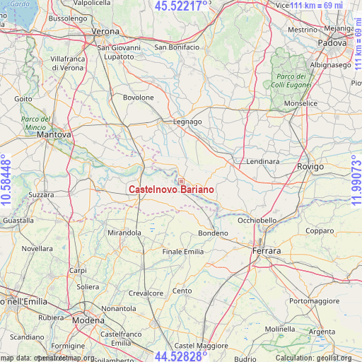
Castelnovo Bariano GPS coordinates[2]
45° 1' 38.568" North, 11° 17' 15.36" East
| Map corner | latitude | longitude |
|---|---|---|
| Upper-left | 45.52217°, | 10.58448° |
| Center: | 45.02738°, | 11.2876° |
| Lower-right: | 44.52828°, | 11.99073° |
| Map W x H: | 110.5×110.5 km | = 68.7×68.7mi |
| max Lat: | 47.04031° ⇑39.4% North |
| Castelnovo Bariano: | 45.02738° |
| min Lat: | ⇓60.6% South 35.50142° |
| min Long | Castelnovo Bari | max Long |
| 6.69888° | 11.2876° | 18.48682° |
| W 46.7%⇐ | ⇒53.3% E |
Elevation
Elevation of Castelnovo Bariano is 10 m = 33 ft, and this is 296.7 m = 973 ft below average elevation for this country.
| Max E: |
2085 m = 6841 ft | 94.1% |
| Avg. | 306.7 m = 1006 ft | |
| Castelnovo Bariano | 10 m = 33 ft | |
Min E: |
-4 m = -13 ft | 5.9% |
See also: Italy elevation on elevation.city.
Geographical zone
Castelnovo Bariano is located in North temperate zone (between Tropic of Cancer and the Arctic Circle). Distance of this North polar circle is 2394.6 km =1487.9 mi to North.| Distance of | km | miles | from Castelnovo Bariano |
|---|---|---|---|
| North Pole | 5000.5 | 3107.2 | to North |
| Arctic Circle | 2394.6 | 1487.9 | to North |
| Tropic Cancer | 2400.7 | 1491.7 | to South |
| Equator | 5006.6 | 3111 | to South |


Nearby cities:
15 places around Castelnovo Bariano: (largest is in red/bold)
• Bergantino
4.7 km =2.9 mi,  323°
323°
• Borgofranco sul Po
6.5 km =4 mi,  289°
289°
• Calto
6.9 km =4.3 mi,  126°
126°
• Carbonara di Po
4.7 km =2.9 mi,  280°
280°
• Castelmassa
2.4 km =1.5 mi,  115°
115°
• Ceneselli
6.6 km =4.1 mi,  103°
103°
• Correggioli
10.3 km =6.4 mi, 294°
• Felonica
7.5 km =4.7 mi,  136°
136°
• Magnacavallo
8.5 km =5.3 mi,  254°
254°
• Melara
7.9 km =4.9 mi,  301°
301°
• Moglia
2.2 km =1.4 mi,  226°
226°
• Pilastri
9 km =5.6 mi,  179°
179°
• Salara
11.9 km =7.4 mi,  112°
112°
• San Martino Spino
11.3 km =7 mi,  202°
202°
• Sermide
2.7 km =1.7 mi,  171°
171°
Sources, notices
• [Note1] Compared only with cities in Italy existing in our database
• [Src1] Map data: © OpenStreetMap contributors (CC-BY-SA)
• [Src2] Other city data from geonames.org with taken over terms of usage.
• [Src3] Geographical zone / Annual Mean Temperature by Robert A. Rohde @ Wikipedia
