Serina geodata
Serina (Lombardy) is a seat of a third-order administrative division; located in Italy in Europe/Rome (GMT+2) time zone. With population of 1,413 people, there are 5329 cities with bigger population in this country. Compared to other cities in Italy, 88.3% of cities are located further ↓South; 70.4% of cities are located further →East and 93.4% of cities have lower elevation than Serina. Note1


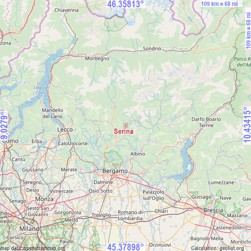
Serina GPS coordinates[2]
45° 52' 14.556" North, 9° 43' 51.672" East
| Map corner | latitude | longitude |
|---|---|---|
| Upper-left | 46.35813°, | 9.0279° |
| Center: | 45.87071°, | 9.73102° |
| Lower-right: | 45.37898°, | 10.43415° |
| Map W x H: | 108.9×108.9 km | = 67.7×67.7mi |
| max Lat: | 47.04031° ⇑11.7% North |
| Serina: | 45.87071° |
| min Lat: | ⇓88.3% South 35.50142° |
| min Long | Serina | max Long |
| 6.69888° | 9.73102° | 18.48682° |
| W 29.6%⇐ | ⇒70.4% E |
Elevation
Elevation of Serina is 814 m = 2671 ft, and this is 507.3 m = 1664 ft above average elevation for this country.
| Max E: |
2085 m = 6841 ft | 6.6% |
| Serina | 814 m 2671 ft | |
| Avg. | 306.7 m = 1006 ft | |
Min E: |
-4 m = -13 ft | 93.4% |
See also: Italy elevation on elevation.city.
Geographical zone
Serina is located in North temperate zone (between Tropic of Cancer and the Arctic Circle). Distance of this North polar circle is 2300.8 km =1429.7 mi to North.| Distance of | km | miles | from Serina |
|---|---|---|---|
| North Pole | 4906.7 | 3048.9 | to North |
| Arctic Circle | 2300.8 | 1429.7 | to North |
| Tropic Cancer | 2494.4 | 1549.9 | to South |
| Equator | 5100.3 | 3169.2 | to South |


Nearby cities:
15 places around Serina: (largest is in red/bold)
• Algua
5 km =3.1 mi,  187°
187°
• Ambria-Spino
7.9 km =4.9 mi,  209°
209°
• Aviatico
8.7 km =5.4 mi,  158°
158°
• Bracca
5.6 km =3.5 mi,  198°
198°
• Camerata Cornello
6.7 km =4.2 mi,  298°
298°
• Cornalba
2.6 km =1.6 mi,  154°
154°
• Costa di Serina
4.3 km =2.7 mi,  168°
168°
• Dossena
2.9 km =1.8 mi,  291°
291°
• Gorno
8.6 km =5.3 mi,  96°
96°
• Oltre Il Colle
3.6 km =2.2 mi,  54°
54°
• Oneta
6.8 km =4.2 mi,  89°
89°
• San Giovanni Bianco
6 km =3.7 mi,  272°
272°
• San Pellegrino Terme
6.4 km =4 mi,  230°
230°
• Villa d'Oneta
6.8 km =4.2 mi, 89°
• Villassio
8.8 km =5.5 mi, 95°
Sources, notices
• [Note1] Compared only with cities in Italy existing in our database
• [Src1] Map data: © OpenStreetMap contributors (CC-BY-SA)
• [Src2] Other city data from geonames.org with taken over terms of usage.
• [Src3] Geographical zone / Annual Mean Temperature by Robert A. Rohde @ Wikipedia
