Cornalba geodata
Cornalba (Lombardy) is a seat of a third-order administrative division; located in Italy in Europe/Rome (GMT+2) time zone. With population of 251 people, there are 10889 cities with bigger population in this country. Compared to other cities in Italy, 87.6% of cities are located further ↓South; 70.3% of cities are located further →East and 94.1% of cities have lower elevation than Cornalba. Note1


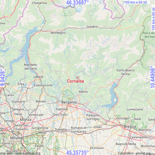
Cornalba GPS coordinates[2]
45° 50' 57.372" North, 9° 44' 45.348" East
| Map corner | latitude | longitude |
|---|---|---|
| Upper-left | 46.33687°, | 9.0428° |
| Center: | 45.84927°, | 9.74593° |
| Lower-right: | 45.35735°, | 10.44906° |
| Map W x H: | 108.9×108.9 km | = 67.7×67.7mi |
| max Lat: | 47.04031° ⇑12.4% North |
| Cornalba: | 45.84927° |
| min Lat: | ⇓87.6% South 35.50142° |
| min Long | Cornalba | max Long |
| 6.69888° | 9.74593° | 18.48682° |
| W 29.7%⇐ | ⇒70.3% E |
Elevation
Elevation of Cornalba is 841 m = 2759 ft, and this is 534.3 m = 1753 ft above average elevation for this country.
| Max E: |
2085 m = 6841 ft | 5.9% |
| Cornalba | 841 m 2759 ft | |
| Avg. | 306.7 m = 1006 ft | |
Min E: |
-4 m = -13 ft | 94.1% |
See also: Italy elevation on elevation.city.
Geographical zone
Cornalba is located in North temperate zone (between Tropic of Cancer and the Arctic Circle). Distance of this North polar circle is 2303.2 km =1431.1 mi to North.| Distance of | km | miles | from Cornalba |
|---|---|---|---|
| North Pole | 4909.1 | 3050.4 | to North |
| Arctic Circle | 2303.2 | 1431.1 | to North |
| Tropic Cancer | 2492 | 1548.5 | to South |
| Equator | 5098 | 3167.7 | to South |


Nearby cities:
15 places around Cornalba: (largest is in red/bold)
• Algua
3.2 km =2 mi,  215°
215°
• Ambria-Spino
6.8 km =4.2 mi,  228°
228°
• Aviatico
6.1 km =3.8 mi,  161°
161°
• Bracca
4.2 km =2.6 mi, 224°
• Costa di Serina
1.9 km =1.2 mi,  190°
190°
• Dossena
5.1 km =3.2 mi,  312°
312°
• Gorno
7.5 km =4.7 mi,  78°
78°
• Oltre Il Colle
4.8 km =3 mi,  21°
21°
• Oneta
6.2 km =3.9 mi,  66°
66°
• Orezzo
7.6 km =4.7 mi,  129°
129°
• San Giovanni Bianco
7.6 km =4.7 mi,  290°
290°
• San Pellegrino Terme
6.3 km =3.9 mi,  254°
254°
• Selvino
7.1 km =4.4 mi,  175°
175°
• Serina
2.6 km =1.6 mi,  334°
334°
• Villa d'Oneta
6.2 km =3.9 mi, 67°
Sources, notices
• [Note1] Compared only with cities in Italy existing in our database
• [Src1] Map data: © OpenStreetMap contributors (CC-BY-SA)
• [Src2] Other city data from geonames.org with taken over terms of usage.
• [Src3] Geographical zone / Annual Mean Temperature by Robert A. Rohde @ Wikipedia
