Scheggino geodata
Scheggino (Umbria) is a seat of a third-order administrative division; located in Italy in Europe/Rome (GMT+2) time zone. With population of 273 people, there are 10789 cities with bigger population in this country. Compared to other cities in Italy, 65.1% of cities are located further ↑North; 66.4% of cities are located further ←West and 57.5% of cities have lower elevation than Scheggino. Note1


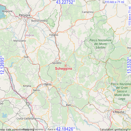
Scheggino GPS coordinates[2]
42° 42' 46.944" North, 12° 49' 48.252" East
| Map corner | latitude | longitude |
|---|---|---|
| Upper-left | 43.22752°, | 12.12695° |
| Center: | 42.71304°, | 12.83007° |
| Lower-right: | 42.19426°, | 13.5332° |
| Map W x H: | 114.9×114.9 km | = 71.4×71.4mi |
| max Lat: | 47.04031° ⇑65.1% North |
| Scheggino: | 42.71304° |
| min Lat: | ⇓34.9% South 35.50142° |
| min Long | Scheggino | max Long |
| 6.69888° | 12.83007° | 18.48682° |
| W 66.4%⇐ | ⇒33.6% E |
Elevation
Elevation of Scheggino is 282 m = 925 ft, and this is 24.7 m = 81 ft below average elevation for this country.
| Max E: |
2085 m = 6841 ft | 42.5% |
| Avg. | 306.7 m = 1006 ft | |
| Scheggino | 282 m = 925 ft | |
Min E: |
-4 m = -13 ft | 57.5% |
See also: Italy elevation on elevation.city.
Geographical zone
Scheggino is located in North temperate zone (between Tropic of Cancer and the Arctic Circle). Distance of this Northern Tropic circle is 2143.3 km =1331.8 mi to South.| Distance of | km | miles | from Scheggino |
|---|---|---|---|
| North Pole | 5257.8 | 3267 | to North |
| Arctic Circle | 2651.9 | 1647.8 | to North |
| Tropic Cancer | 2143.3 | 1331.8 | to South |
| Equator | 4749.2 | 2951 | to South |


Nearby cities:
15 places around Scheggino: (largest is in red/bold)
• Arrone
15.4 km =9.6 mi,  199°
199°
• Campello sul Clitunno
13.6 km =8.5 mi,  338°
338°
• Cascia
15.3 km =9.5 mi,  87°
87°
• Cerreto di Spoleto
14.2 km =8.8 mi,  31°
31°
• Cortaccione
8.1 km =5 mi,  314°
314°
• Ferentillo
10.9 km =6.8 mi, 198°
• Meggiano
5.4 km =3.4 mi, 30°
• Montefranco
13.9 km =8.6 mi, 203°
• Monteleone di Spoleto
12.1 km =7.5 mi,  125°
125°
• Poggiodomo
8.4 km =5.2 mi, 90°
• Polino
14.4 km =8.9 mi,  175°
175°
• San Giacomo
11 km =6.8 mi,  324°
324°
• San Martino in Trignano
13.6 km =8.5 mi,  283°
283°
• Sant'Anatolia di Narco
2.3 km =1.4 mi,  11°
11°
• Spoleto
8.1 km =5 mi,  292°
292°
Sources, notices
• [Note1] Compared only with cities in Italy existing in our database
• [Src1] Map data: © OpenStreetMap contributors (CC-BY-SA)
• [Src2] Other city data from geonames.org with taken over terms of usage.
• [Src3] Geographical zone / Annual Mean Temperature by Robert A. Rohde @ Wikipedia
