Ferentillo geodata
Ferentillo (Umbria) is a seat of a third-order administrative division; located in Italy in Europe/Rome (GMT+2) time zone. With population of 1,272 people, there are 5721 cities with bigger population in this country. Compared to other cities in Italy, 65.6% of cities are located further ↑North; 66% of cities are located further ←West and 52.1% of cities have lower elevation than Ferentillo. Note1


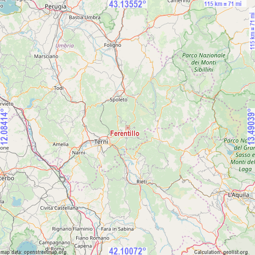
Ferentillo GPS coordinates[2]
42° 37' 12.972" North, 12° 47' 14.136" East
| Map corner | latitude | longitude |
|---|---|---|
| Upper-left | 43.13552°, | 12.08414° |
| Center: | 42.62027°, | 12.78726° |
| Lower-right: | 42.10072°, | 13.49039° |
| Map W x H: | 115.1×115.1 km | = 71.5×71.5mi |
| max Lat: | 47.04031° ⇑65.6% North |
| Ferentillo: | 42.62027° |
| min Lat: | ⇓34.4% South 35.50142° |
| min Long | Ferentillo | max Long |
| 6.69888° | 12.78726° | 18.48682° |
| W 66%⇐ | ⇒34% E |
Elevation
Elevation of Ferentillo is 247 m = 810 ft, and this is 59.7 m = 196 ft below average elevation for this country.
| Max E: |
2085 m = 6841 ft | 47.9% |
| Avg. | 306.7 m = 1006 ft | |
| Ferentillo | 247 m = 810 ft | |
Min E: |
-4 m = -13 ft | 52.1% |
See also: Italy elevation on elevation.city.
Geographical zone
Ferentillo is located in North temperate zone (between Tropic of Cancer and the Arctic Circle). Distance of this Northern Tropic circle is 2133 km =1325.4 mi to South.| Distance of | km | miles | from Ferentillo |
|---|---|---|---|
| North Pole | 5268.1 | 3273.4 | to North |
| Arctic Circle | 2662.2 | 1654.2 | to North |
| Tropic Cancer | 2133 | 1325.4 | to South |
| Equator | 4738.9 | 2944.6 | to South |


Nearby cities:
15 places around Ferentillo: (largest is in red/bold)
• Arrone
4.5 km =2.8 mi,  201°
201°
• Colli sul Velino
13.6 km =8.5 mi,  181°
181°
• Labro
10.5 km =6.5 mi,  174°
174°
• Leonessa
15.3 km =9.5 mi,  112°
112°
• Marmore
10 km =6.2 mi,  216°
216°
• Montefranco
3.1 km =1.9 mi, 218°
• Monteleone di Spoleto
13.9 km =8.6 mi,  75°
75°
• Morro Reatino
11.6 km =7.2 mi,  160°
160°
• Polino
6.2 km =3.9 mi,  130°
130°
• Rivodutri
12.8 km =8 mi,  153°
153°
• Roman catholic diocese of Terni
13.5 km =8.4 mi,  240°
240°
• Sant'Anatolia di Narco
13.2 km =8.2 mi,  17°
17°
• Scheggino
10.9 km =6.8 mi, 18°
• Spoleto
14 km =8.7 mi,  343°
343°
• Terni
13.4 km =8.3 mi, 241°
Sources, notices
• [Note1] Compared only with cities in Italy existing in our database
• [Src1] Map data: © OpenStreetMap contributors (CC-BY-SA)
• [Src2] Other city data from geonames.org with taken over terms of usage.
• [Src3] Geographical zone / Annual Mean Temperature by Robert A. Rohde @ Wikipedia
