Savio geodata
Savio (Emilia-Romagna) is a populated place; located in Italy in Europe/Rome (GMT+2) time zone. With population of 1,487 people, there are 5146 cities with bigger population in this country. Compared to other cities in Italy, 51.8% of cities are located further ↑North; 59.8% of cities are located further ←West and 99.4% of cities have higher elevation than Savio. Note1


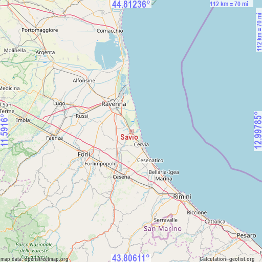
Savio GPS coordinates[2]
44° 18' 41.004" North, 12° 17' 40.992" East
| Map corner | latitude | longitude |
|---|---|---|
| Upper-left | 44.81236°, | 11.5916° |
| Center: | 44.31139°, | 12.29472° |
| Lower-right: | 43.80611°, | 12.99785° |
| Map W x H: | 111.9×111.9 km | = 69.5×69.5mi |
| max Lat: | 47.04031° ⇑51.8% North |
| Savio: | 44.31139° |
| min Lat: | ⇓48.2% South 35.50142° |
| min Long | Savio | max Long |
| 6.69888° | 12.29472° | 18.48682° |
| W 59.8%⇐ | ⇒40.2% E |
Elevation
Elevation of Savio is 1 m = 3 ft, and this is 305.7 m = 1003 ft below average elevation for this country.
| Max E: |
2085 m = 6841 ft | 99.4% |
| Avg. | 306.7 m = 1006 ft | |
| Savio | 1 m = 3 ft | |
Min E: |
-4 m = -13 ft | 0.6% |
See also: Italy elevation on elevation.city.
Geographical zone
Savio is located in North temperate zone (between Tropic of Cancer and the Arctic Circle). Distance of this Northern Tropic circle is 2321 km =1442.2 mi to South.| Distance of | km | miles | from Savio |
|---|---|---|---|
| North Pole | 5080.1 | 3156.6 | to North |
| Arctic Circle | 2474.2 | 1537.4 | to North |
| Tropic Cancer | 2321 | 1442.2 | to South |
| Equator | 4927 | 3061.5 | to South |


Nearby cities:
15 places around Savio: (largest is in red/bold)
• Campiano
7.8 km =4.8 mi,  259°
259°
• Cannuzzo
9.5 km =5.9 mi,  206°
206°
• Cervia
6.9 km =4.3 mi,  142°
142°
• Classe
8.9 km =5.5 mi,  328°
328°
• Fosso Ghiaia
5.8 km =3.6 mi, 326°
• Lido di Classe
3.8 km =2.4 mi,  58°
58°
• Lido di Savio
3.8 km =2.4 mi,  83°
83°
• Milano Marittima
6.1 km =3.8 mi,  132°
132°
• Pinarella
9.9 km =6.2 mi, 141°
• Pisignano
8.4 km =5.2 mi,  194°
194°
• Romea Vecchia
10 km =6.2 mi, 330°
• San Bartolo
10.7 km =6.6 mi,  301°
301°
• San Zaccaria
7.9 km =4.9 mi,  234°
234°
• Santo Stefano-Carraie
8.7 km =5.4 mi,  272°
272°
• Villa Inferno
9.1 km =5.7 mi,  168°
168°
Sources, notices
• [Note1] Compared only with cities in Italy existing in our database
• [Src1] Map data: © OpenStreetMap contributors (CC-BY-SA)
• [Src2] Other city data from geonames.org with taken over terms of usage.
• [Src3] Geographical zone / Annual Mean Temperature by Robert A. Rohde @ Wikipedia
