Cervia geodata
Cervia (Emilia-Romagna) is a seat of a third-order administrative division; located in Italy in Europe/Rome (GMT+2) time zone. With population of 20,487 people, there are 432 cities with bigger population in this country. Compared to other cities in Italy, 52.2% of cities are located further ↑North; 60.6% of cities are located further ←West and 98.4% of cities have higher elevation than Cervia. Note1


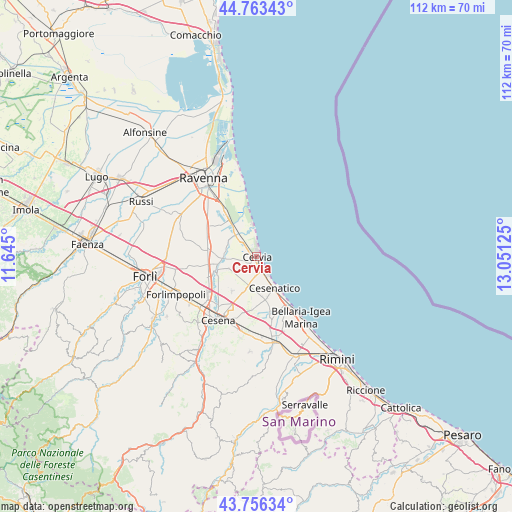
Cervia GPS coordinates[2]
44° 15' 43.344" North, 12° 20' 53.232" East
| Map corner | latitude | longitude |
|---|---|---|
| Upper-left | 44.76343°, | 11.645° |
| Center: | 44.26204°, | 12.34812° |
| Lower-right: | 43.75634°, | 13.05125° |
| Map W x H: | 112×112 km | = 69.6×69.6mi |
| max Lat: | 47.04031° ⇑52.2% North |
| Cervia: | 44.26204° |
| min Lat: | ⇓47.8% South 35.50142° |
| min Long | Cervia | max Long |
| 6.69888° | 12.34812° | 18.48682° |
| W 60.6%⇐ | ⇒39.4% E |
Elevation
Elevation of Cervia is 3 m = 10 ft, and this is 303.7 m = 996 ft below average elevation for this country.
| Max E: |
2085 m = 6841 ft | 98.4% |
| Avg. | 306.7 m = 1006 ft | |
| Cervia | 3 m = 10 ft | |
Min E: |
-4 m = -13 ft | 1.6% |
See also: Italy elevation on elevation.city.
Geographical zone
Cervia is located in North temperate zone (between Tropic of Cancer and the Arctic Circle). Distance of this Northern Tropic circle is 2315.6 km =1438.8 mi to South.| Distance of | km | miles | from Cervia |
|---|---|---|---|
| North Pole | 5085.6 | 3160 | to North |
| Arctic Circle | 2479.7 | 1540.8 | to North |
| Tropic Cancer | 2315.6 | 1438.8 | to South |
| Equator | 4921.5 | 3058.1 | to South |


Nearby cities:
15 places around Cervia: (largest is in red/bold)
• Bagnarola
11.1 km =6.9 mi,  182°
182°
• Campiano
12.6 km =7.8 mi,  288°
288°
• Cannuzzo
9 km =5.6 mi,  250°
250°
• Cesenatico
8 km =5 mi,  149°
149°
• Fosso Ghiaia
12.8 km =8 mi,  324°
324°
• Gatteo a Mare
12.3 km =7.6 mi, 145°
• Lido di Classe
7.5 km =4.7 mi,  351°
351°
• Lido di Savio
5.9 km =3.7 mi,  355°
355°
• Milano Marittima
1.4 km =0.9 mi,  12°
12°
• Pinarella
2.9 km =1.8 mi,  141°
141°
• Pisignano
6.9 km =4.3 mi, 247°
• Sala
12.1 km =7.5 mi,  166°
166°
• San Zaccaria
10.7 km =6.6 mi,  275°
275°
• Savio
6.9 km =4.3 mi, 322°
• Villa Inferno
4.2 km =2.6 mi,  214°
214°
Sources, notices
• [Note1] Compared only with cities in Italy existing in our database
• [Src1] Map data: © OpenStreetMap contributors (CC-BY-SA)
• [Src2] Other city data from geonames.org with taken over terms of usage.
• [Src3] Geographical zone / Annual Mean Temperature by Robert A. Rohde @ Wikipedia
