Cannuzzo geodata
Cannuzzo (Emilia-Romagna) is a populated place; located in Italy in Europe/Rome (GMT+2) time zone. With population of 575 people, there are 9221 cities with bigger population in this country. Compared to other cities in Italy, 52.5% of cities are located further ↑North; 59.2% of cities are located further ←West and 92.1% of cities have higher elevation than Cannuzzo. Note1


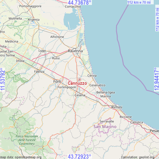
Cannuzzo GPS coordinates[2]
44° 14' 6.576" North, 12° 14' 27.744" East
| Map corner | latitude | longitude |
|---|---|---|
| Upper-left | 44.73678°, | 11.53792° |
| Center: | 44.23516°, | 12.24104° |
| Lower-right: | 43.72923°, | 12.94417° |
| Map W x H: | 112×112 km | = 69.6×69.6mi |
| max Lat: | 47.04031° ⇑52.5% North |
| Cannuzzo: | 44.23516° |
| min Lat: | ⇓47.5% South 35.50142° |
| min Long | Cannuzzo | max Long |
| 6.69888° | 12.24104° | 18.48682° |
| W 59.2%⇐ | ⇒40.8% E |
Elevation
Elevation of Cannuzzo is 14 m = 46 ft, and this is 292.7 m = 960 ft below average elevation for this country.
| Max E: |
2085 m = 6841 ft | 92.1% |
| Avg. | 306.7 m = 1006 ft | |
| Cannuzzo | 14 m = 46 ft | |
Min E: |
-4 m = -13 ft | 7.9% |
See also: Italy elevation on elevation.city.
Geographical zone
Cannuzzo is located in North temperate zone (between Tropic of Cancer and the Arctic Circle). Distance of this Northern Tropic circle is 2312.6 km =1437 mi to South.| Distance of | km | miles | from Cannuzzo |
|---|---|---|---|
| North Pole | 5088.6 | 3161.9 | to North |
| Arctic Circle | 2482.7 | 1542.7 | to North |
| Tropic Cancer | 2312.6 | 1437 | to South |
| Equator | 4918.5 | 3056.2 | to South |


Nearby cities:
15 places around Cannuzzo: (largest is in red/bold)
• Campiano
7.9 km =4.9 mi,  333°
333°
• Capocolle
9.4 km =5.8 mi,  213°
213°
• Carpinello
9.7 km =6 mi,  272°
272°
• Cervia
9 km =5.6 mi,  70°
70°
• Forlimpopoli
10.2 km =6.3 mi,  241°
241°
• Milano Marittima
9.8 km =6.1 mi,  63°
63°
• Panighina
9.4 km =5.8 mi,  221°
221°
• Pinarella
10.4 km =6.5 mi,  86°
86°
• Pisignano
2.2 km =1.4 mi,  82°
82°
• San Pietro In Vincoli
10.5 km =6.5 mi,  313°
313°
• San Zaccaria
4.5 km =2.8 mi, 331°
• Santa Maria Nuova
5.4 km =3.4 mi, 223°
• Santo Stefano-Carraie
9.9 km =6.2 mi, 333°
• Savio
9.5 km =5.9 mi,  26°
26°
• Villa Inferno
6.1 km =3.8 mi, 94°
Sources, notices
• [Note1] Compared only with cities in Italy existing in our database
• [Src1] Map data: © OpenStreetMap contributors (CC-BY-SA)
• [Src2] Other city data from geonames.org with taken over terms of usage.
• [Src3] Geographical zone / Annual Mean Temperature by Robert A. Rohde @ Wikipedia
