Sassa geodata
Sassa (Abruzzo) is a populated place; located in Italy in Europe/Rome (GMT+2) time zone. With population of 1,557 people, there are 4985 cities with bigger population in this country. Compared to other cities in Italy, 67.2% of cities are located further ↑North; 71.4% of cities are located further ←West and 88.6% of cities have lower elevation than Sassa. Note1


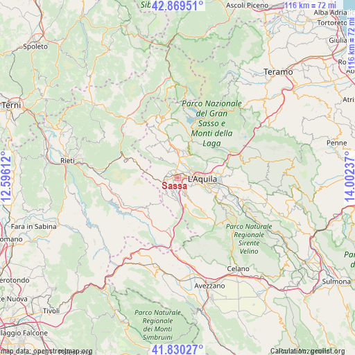
Sassa GPS coordinates[2]
42° 21' 7.344" North, 13° 17' 57.264" East
| Map corner | latitude | longitude |
|---|---|---|
| Upper-left | 42.86951°, | 12.59612° |
| Center: | 42.35204°, | 13.29924° |
| Lower-right: | 41.83027°, | 14.00237° |
| Map W x H: | 115.6×115.6 km | = 71.8×71.8mi |
| max Lat: | 47.04031° ⇑67.2% North |
| Sassa: | 42.35204° |
| min Lat: | ⇓32.8% South 35.50142° |
| min Long | Sassa | max Long |
| 6.69888° | 13.29924° | 18.48682° |
| W 71.4%⇐ | ⇒28.6% E |
Elevation
Elevation of Sassa is 684 m = 2244 ft, and this is 377.3 m = 1238 ft above average elevation for this country.
| Max E: |
2085 m = 6841 ft | 11.4% |
| Sassa | 684 m 2244 ft | |
| Avg. | 306.7 m = 1006 ft | |
Min E: |
-4 m = -13 ft | 88.6% |
See also: Italy elevation on elevation.city.
Geographical zone
Sassa is located in North temperate zone (between Tropic of Cancer and the Arctic Circle). Distance of this Northern Tropic circle is 2103.2 km =1306.9 mi to South.| Distance of | km | miles | from Sassa |
|---|---|---|---|
| North Pole | 5298 | 3292 | to North |
| Arctic Circle | 2692.1 | 1672.8 | to North |
| Tropic Cancer | 2103.2 | 1306.9 | to South |
| Equator | 4709.1 | 2926.1 | to South |


Nearby cities:
15 places around Sassa: (largest is in red/bold)
• Arischia
8.1 km =5 mi,  24°
24°
• Coppito
4 km =2.5 mi,  65°
65°
• L'Aquila
8.2 km =5.1 mi,  91°
91°
• Lucoli
7.5 km =4.7 mi,  154°
154°
• Pianola
9.2 km =5.7 mi,  110°
110°
• Pizzoli
9.3 km =5.8 mi,  359°
359°
• Poggio di Roio
6.8 km =4.2 mi, 109°
• Preturo
2.9 km =1.8 mi, 355°
• Progetto Case Coppito 3
2.6 km =1.6 mi,  40°
40°
• Progetto Case Sassa Nsi
2 km =1.2 mi, 40°
• Roio Piano
5.5 km =3.4 mi,  119°
119°
• San Nicola
5.9 km =3.7 mi,  200°
200°
• Scoppito
3.8 km =2.4 mi,  300°
300°
• Tornimparte
6.9 km =4.3 mi,  178°
178°
• Villagrande
6.3 km =3.9 mi, 179°
Sources, notices
• [Note1] Compared only with cities in Italy existing in our database
• [Src1] Map data: © OpenStreetMap contributors (CC-BY-SA)
• [Src2] Other city data from geonames.org with taken over terms of usage.
• [Src3] Geographical zone / Annual Mean Temperature by Robert A. Rohde @ Wikipedia
