Coppito geodata
Coppito (Abruzzo) is a populated place; located in Italy in Europe/Rome (GMT+2) time zone. With population of 2,903 people, there are 3116 cities with bigger population in this country. Compared to other cities in Italy, 67.1% of cities are located further ↑North; 71.9% of cities are located further ←West and 87.1% of cities have lower elevation than Coppito. Note1


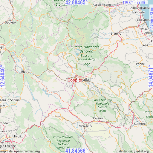
Coppito GPS coordinates[2]
42° 22' 2.28" North, 13° 20' 36.888" East
| Map corner | latitude | longitude |
|---|---|---|
| Upper-left | 42.88465°, | 12.64046° |
| Center: | 42.3673°, | 13.34358° |
| Lower-right: | 41.84566°, | 14.04671° |
| Map W x H: | 115.5×115.5 km | = 71.8×71.8mi |
| max Lat: | 47.04031° ⇑67.1% North |
| Coppito: | 42.3673° |
| min Lat: | ⇓32.9% South 35.50142° |
| min Long | Coppito | max Long |
| 6.69888° | 13.34358° | 18.48682° |
| W 71.9%⇐ | ⇒28.1% E |
Elevation
Elevation of Coppito is 655 m = 2149 ft, and this is 348.3 m = 1143 ft above average elevation for this country.
| Max E: |
2085 m = 6841 ft | 12.9% |
| Coppito | 655 m 2149 ft | |
| Avg. | 306.7 m = 1006 ft | |
Min E: |
-4 m = -13 ft | 87.1% |
See also: Italy elevation on elevation.city.
Geographical zone
Coppito is located in North temperate zone (between Tropic of Cancer and the Arctic Circle). Distance of this Northern Tropic circle is 2104.9 km =1307.9 mi to South.| Distance of | km | miles | from Coppito |
|---|---|---|---|
| North Pole | 5296.3 | 3291 | to North |
| Arctic Circle | 2690.4 | 1671.7 | to North |
| Tropic Cancer | 2104.9 | 1307.9 | to South |
| Equator | 4710.8 | 2927.2 | to South |


Nearby cities:
15 places around Coppito: (largest is in red/bold)
• Arischia
5.7 km =3.5 mi,  357°
357°
• Collebrincioni
6.8 km =4.2 mi,  59°
59°
• L'Aquila
5 km =3.1 mi,  112°
112°
• Lucoli
8.5 km =5.3 mi,  183°
183°
• Pianola
7 km =4.3 mi,  134°
134°
• Pizzoli
8.5 km =5.3 mi,  334°
334°
• Poggio di Roio
4.8 km =3 mi,  144°
144°
• Preturo
4.1 km =2.5 mi,  287°
287°
• Progetto Case Coppito 3
2 km =1.2 mi,  278°
278°
• Progetto Case Sassa Nsi
2.3 km =1.4 mi,  265°
265°
• Roio Piano
4.5 km =2.8 mi,  165°
165°
• San Cipriano
6.6 km =4.1 mi,  123°
123°
• Sassa
4 km =2.5 mi,  245°
245°
• Scoppito
6.9 km =4.3 mi, 272°
• Villagrande
8.8 km =5.5 mi,  204°
204°
Sources, notices
• [Note1] Compared only with cities in Italy existing in our database
• [Src1] Map data: © OpenStreetMap contributors (CC-BY-SA)
• [Src2] Other city data from geonames.org with taken over terms of usage.
• [Src3] Geographical zone / Annual Mean Temperature by Robert A. Rohde @ Wikipedia
