L'Aquila geodata
L'Aquila (Abruzzo) is a seat of a first-order administrative division; located in Italy in Europe/Rome (GMT+2) time zone. With population of 33,691 people, there are 230 cities with bigger population in this country. Compared to other cities in Italy, 67.3% of cities are located further ↑North; 72.4% of cities are located further ←West and 90.3% of cities have lower elevation than L'Aquila. Note1


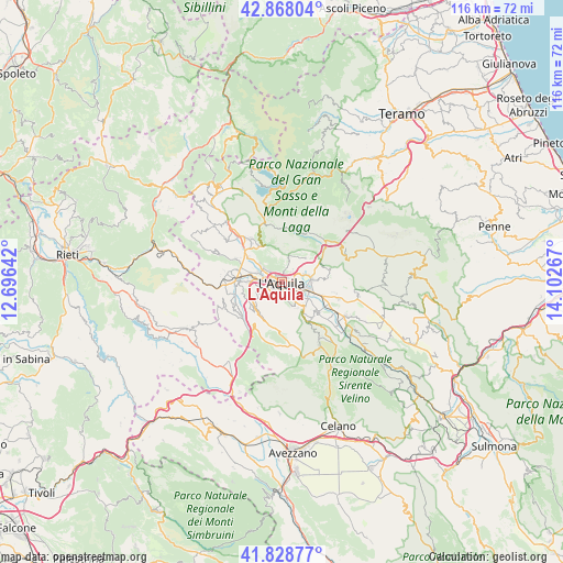
L'Aquila GPS coordinates[2]
42° 21' 1.98" North, 13° 23' 58.344" East
| Map corner | latitude | longitude |
|---|---|---|
| Upper-left | 42.86804°, | 12.69642° |
| Center: | 42.35055°, | 13.39954° |
| Lower-right: | 41.82877°, | 14.10267° |
| Map W x H: | 115.6×115.6 km | = 71.8×71.8mi |
| max Lat: | 47.04031° ⇑67.3% North |
| L'Aquila: | 42.35055° |
| min Lat: | ⇓32.7% South 35.50142° |
| min Long | L'Aquila | max Long |
| 6.69888° | 13.39954° | 18.48682° |
| W 72.4%⇐ | ⇒27.6% E |
Elevation
Elevation of L'Aquila is 728 m = 2388 ft, and this is 421.3 m = 1382 ft above average elevation for this country.
| Max E: |
2085 m = 6841 ft | 9.7% |
| L'Aquila | 728 m 2388 ft | |
| Avg. | 306.7 m = 1006 ft | |
Min E: |
-4 m = -13 ft | 90.3% |
See also: Italy elevation on elevation.city.
Geographical zone
L'Aquila is located in North temperate zone (between Tropic of Cancer and the Arctic Circle). Distance of this Northern Tropic circle is 2103 km =1306.7 mi to South.| Distance of | km | miles | from L'Aquila |
|---|---|---|---|
| North Pole | 5298.1 | 3292.1 | to North |
| Arctic Circle | 2692.2 | 1672.9 | to North |
| Tropic Cancer | 2103 | 1306.7 | to South |
| Equator | 4708.9 | 2926 | to South |


Nearby cities:
15 places around L'Aquila: (largest is in red/bold)
• Collebrincioni
5.4 km =3.4 mi,  13°
13°
• Cominio
5 km =3.1 mi,  147°
147°
• Coppito
5 km =3.1 mi,  292°
292°
• Lucoli
8.3 km =5.2 mi,  217°
217°
• Monticchio
6.3 km =3.9 mi,  122°
122°
• Nucleo Industriale di Bazzano
5.8 km =3.6 mi,  105°
105°
• Paganica-Tempera
5.9 km =3.7 mi,  82°
82°
• Pianola
3 km =1.9 mi,  173°
173°
• Poggio di Roio
2.8 km =1.7 mi, 220°
• Progetto Case Bazzano
4 km =2.5 mi, 113°
• Progetto Case Coppito 3
6.9 km =4.3 mi, 288°
• Progetto Case Sassa Nsi
7.1 km =4.4 mi,  283°
283°
• Roio Piano
4.3 km =2.7 mi,  234°
234°
• San Cipriano
2 km =1.2 mi, 153°
• Sassa
8.2 km =5.1 mi,  271°
271°
Sources, notices
• [Note1] Compared only with cities in Italy existing in our database
• [Src1] Map data: © OpenStreetMap contributors (CC-BY-SA)
• [Src2] Other city data from geonames.org with taken over terms of usage.
• [Src3] Geographical zone / Annual Mean Temperature by Robert A. Rohde @ Wikipedia
