Sarezzo geodata
Sarezzo (Lombardy) is a seat of a third-order administrative division; located in Italy in Europe/Rome (GMT+2) time zone. With population of 13,295 people, there are 689 cities with bigger population in this country. Compared to other cities in Italy, 79.5% of cities are located further ↓South; 66% of cities are located further →East and 56.5% of cities have lower elevation than Sarezzo. Note1


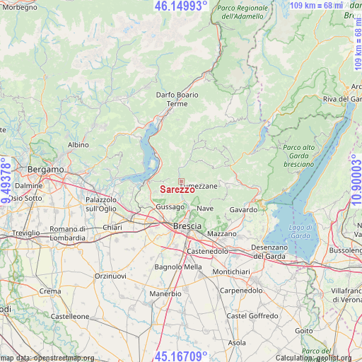
Sarezzo GPS coordinates[2]
45° 39' 38.412" North, 10° 11' 48.84" East
| Map corner | latitude | longitude |
|---|---|---|
| Upper-left | 46.14993°, | 9.49378° |
| Center: | 45.66067°, | 10.1969° |
| Lower-right: | 45.16709°, | 10.90003° |
| Map W x H: | 109.3×109.3 km | = 67.9×67.9mi |
| max Lat: | 47.04031° ⇑20.5% North |
| Sarezzo: | 45.66067° |
| min Lat: | ⇓79.5% South 35.50142° |
| min Long | Sarezzo | max Long |
| 6.69888° | 10.1969° | 18.48682° |
| W 34%⇐ | ⇒66% E |
Elevation
Elevation of Sarezzo is 275 m = 902 ft, and this is 31.7 m = 104 ft below average elevation for this country.
| Max E: |
2085 m = 6841 ft | 43.5% |
| Avg. | 306.7 m = 1006 ft | |
| Sarezzo | 275 m = 902 ft | |
Min E: |
-4 m = -13 ft | 56.5% |
See also: Italy elevation on elevation.city.
Geographical zone
Sarezzo is located in North temperate zone (between Tropic of Cancer and the Arctic Circle). Distance of this North polar circle is 2324.2 km =1444.2 mi to North.| Distance of | km | miles | from Sarezzo |
|---|---|---|---|
| North Pole | 4930.1 | 3063.4 | to North |
| Arctic Circle | 2324.2 | 1444.2 | to North |
| Tropic Cancer | 2471.1 | 1535.5 | to South |
| Equator | 5077 | 3154.7 | to South |


Nearby cities:
15 places around Sarezzo: (largest is in red/bold)
• Brione
4.3 km =2.7 mi,  241°
241°
• Brozzo
7.1 km =4.4 mi,  21°
21°
• Concesio
6.4 km =4 mi,  165°
165°
• Gardone Val Trompia
3.5 km =2.2 mi,  346°
346°
• Lumezzane
5.5 km =3.4 mi,  105°
105°
• Magno
5.1 km =3.2 mi,  2°
2°
• Marcheno
5.3 km =3.3 mi, 15°
• Monticelli Brusati
8 km =5 mi,  249°
249°
• Ome
6.9 km =4.3 mi, 237°
• Polaveno
5.7 km =3.5 mi,  270°
270°
• San Sebastiano
4.8 km =3 mi,  101°
101°
• San Vigilio
5.9 km =3.7 mi,  181°
181°
• San Zenone
4.4 km =2.7 mi, 241°
• Sulzano
8.1 km =5 mi,  291°
291°
• Villa Carcina
3 km =1.9 mi, 181°
Sources, notices
• [Note1] Compared only with cities in Italy existing in our database
• [Src1] Map data: © OpenStreetMap contributors (CC-BY-SA)
• [Src2] Other city data from geonames.org with taken over terms of usage.
• [Src3] Geographical zone / Annual Mean Temperature by Robert A. Rohde @ Wikipedia
