Marcheno geodata
Marcheno (Lombardy) is a seat of a third-order administrative division; located in Italy in Europe/Rome (GMT+2) time zone. With population of 3,110 people, there are 2949 cities with bigger population in this country. Compared to other cities in Italy, 81.5% of cities are located further ↓South; 65.9% of cities are located further →East and 67.8% of cities have lower elevation than Marcheno. Note1


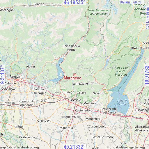
Marcheno GPS coordinates[2]
45° 42' 23.364" North, 10° 12' 52.164" East
| Map corner | latitude | longitude |
|---|---|---|
| Upper-left | 46.19535°, | 9.51137° |
| Center: | 45.70649°, | 10.21449° |
| Lower-right: | 45.21332°, | 10.91762° |
| Map W x H: | 109.2×109.2 km | = 67.9×67.9mi |
| max Lat: | 47.04031° ⇑18.5% North |
| Marcheno: | 45.70649° |
| min Lat: | ⇓81.5% South 35.50142° |
| min Long | Marcheno | max Long |
| 6.69888° | 10.21449° | 18.48682° |
| W 34.1%⇐ | ⇒65.9% E |
Elevation
Elevation of Marcheno is 372 m = 1220 ft, and this is 65.3 m = 214 ft above average elevation for this country.
| Max E: |
2085 m = 6841 ft | 32.2% |
| Marcheno | 372 m 1220 ft | |
| Avg. | 306.7 m = 1006 ft | |
Min E: |
-4 m = -13 ft | 67.8% |
See also: Italy elevation on elevation.city.
Geographical zone
Marcheno is located in North temperate zone (between Tropic of Cancer and the Arctic Circle). Distance of this North polar circle is 2319.1 km =1441 mi to North.| Distance of | km | miles | from Marcheno |
|---|---|---|---|
| North Pole | 4925 | 3060.3 | to North |
| Arctic Circle | 2319.1 | 1441 | to North |
| Tropic Cancer | 2476.2 | 1538.6 | to South |
| Equator | 5082.1 | 3157.9 | to South |


Nearby cities:
15 places around Marcheno: (largest is in red/bold)
• Briale
8 km =5 mi,  92°
92°
• Brozzo
2 km =1.2 mi,  39°
39°
• Dosso-Ville
6.9 km =4.3 mi, 42°
• Gardone Val Trompia
2.8 km =1.7 mi,  232°
232°
• Lodrino
5.1 km =3.2 mi,  73°
73°
• Lumezzane
7.6 km =4.7 mi,  149°
149°
• Magno
1.2 km =0.7 mi,  270°
270°
• Marmentino
7.7 km =4.8 mi,  45°
45°
• Pezzaze
7.9 km =4.9 mi,  12°
12°
• Sale Marasino
7.9 km =4.9 mi, 269°
• San Sebastiano
6.9 km =4.3 mi, 151°
• Sarezzo
5.3 km =3.3 mi,  195°
195°
• Stravignino
7.8 km =4.8 mi, 13°
• Tavernole
4.8 km =3 mi,  23°
23°
• Villa
5.2 km =3.2 mi,  75°
75°
Sources, notices
• [Note1] Compared only with cities in Italy existing in our database
• [Src1] Map data: © OpenStreetMap contributors (CC-BY-SA)
• [Src2] Other city data from geonames.org with taken over terms of usage.
• [Src3] Geographical zone / Annual Mean Temperature by Robert A. Rohde @ Wikipedia
