Mairano geodata
Mairano (Lombardy) is a populated place; located in Italy in Europe/Rome (GMT+2) time zone. With population of 1,991 people, there are 4173 cities with bigger population in this country. Compared to other cities in Italy, 67.7% of cities are located further ↓South; 75.3% of cities are located further →East and 73.3% of cities have higher elevation than Mairano. Note1
Administrative division(s):
- Level 1: Lombardy
- Level 2: Provincia di Lodi
- Level 3: Casaletto Lodigiano


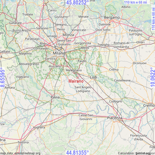
Mairano GPS coordinates[2]
45° 18' 36.684" North, 9° 21' 32.652" East
| Map corner | latitude | longitude |
|---|---|---|
| Upper-left | 45.80252°, | 8.65595° |
| Center: | 45.31019°, | 9.35907° |
| Lower-right: | 44.81355°, | 10.0622° |
| Map W x H: | 110×110 km | = 68.4×68.4mi |
| max Lat: | 47.04031° ⇑32.3% North |
| Mairano: | 45.31019° |
| min Lat: | ⇓67.7% South 35.50142° |
| min Long | Mairano | max Long |
| 6.69888° | 9.35907° | 18.48682° |
| W 24.7%⇐ | ⇒75.3% E |
Elevation
Elevation of Mairano is 82 m = 269 ft, and this is 224.7 m = 737 ft below average elevation for this country.
| Max E: |
2085 m = 6841 ft | 73.3% |
| Avg. | 306.7 m = 1006 ft | |
| Mairano | 82 m = 269 ft | |
Min E: |
-4 m = -13 ft | 26.7% |
See also: Italy elevation on elevation.city.
Geographical zone
Mairano is located in North temperate zone (between Tropic of Cancer and the Arctic Circle). Distance of this North polar circle is 2363.2 km =1468.4 mi to North.| Distance of | km | miles | from Mairano |
|---|---|---|---|
| North Pole | 4969 | 3087.6 | to North |
| Arctic Circle | 2363.2 | 1468.4 | to North |
| Tropic Cancer | 2432.1 | 1511.2 | to South |
| Equator | 5038 | 3130.5 | to South |


Nearby cities:
15 places around Mairano: (largest is in red/bold)
• Bascapè
3.6 km =2.2 mi,  262°
262°
• Calvenzano
4.8 km =3 mi,  160°
160°
• Casaletto Lodigiano
1.9 km =1.2 mi,  173°
173°
• Casalmaiocco
4.8 km =3 mi,  11°
11°
• Caselle Lurani
3.3 km =2.1 mi,  178°
178°
• Cerro al Lambro
2.7 km =1.7 mi,  324°
324°
• Lodi Vecchio
4.6 km =2.9 mi,  98°
98°
• Pairana
5.7 km =3.5 mi,  281°
281°
• Riozzo
5 km =3.1 mi, 323°
• Salerano sul Lambro
2.5 km =1.6 mi,  126°
126°
• San Zenone al Lambro
1.9 km =1.2 mi,  352°
352°
• Sordio
3.6 km =2.2 mi, 5°
• Tavazzano
4.1 km =2.5 mi,  61°
61°
• Vigonzone
5.6 km =3.5 mi,  223°
223°
• Vizzolo Predabissi
5.2 km =3.2 mi, 350°
Sources, notices
• [Note1] Compared only with cities in Italy existing in our database
• [Src1] Map data: © OpenStreetMap contributors (CC-BY-SA)
• [Src2] Other city data from geonames.org with taken over terms of usage.
• [Src3] Geographical zone / Annual Mean Temperature by Robert A. Rohde @ Wikipedia
