Sant'Elena geodata
Sant'Elena (Veneto) is a seat of a third-order administrative division; located in Italy in Europe/Rome (GMT+2) time zone. With population of 1,637 people, there are 4808 cities with bigger population in this country. Compared to other cities in Italy, 64.6% of cities are located further ↓South; 52% of cities are located further ←West and 95.3% of cities have higher elevation than Sant'Elena. Note1


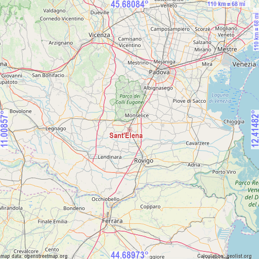
Sant'Elena GPS coordinates[2]
45° 11' 14.784" North, 11° 42' 42.084" East
| Map corner | latitude | longitude |
|---|---|---|
| Upper-left | 45.68084°, | 11.00857° |
| Center: | 45.18744°, | 11.71169° |
| Lower-right: | 44.68973°, | 12.41482° |
| Map W x H: | 110.2×110.2 km | = 68.5×68.5mi |
| max Lat: | 47.04031° ⇑35.4% North |
| Sant'Elena: | 45.18744° |
| min Lat: | ⇓64.6% South 35.50142° |
| min Long | Sant'Elena | max Long |
| 6.69888° | 11.71169° | 18.48682° |
| W 52%⇐ | ⇒48% E |
Elevation
Elevation of Sant'Elena is 8 m = 26 ft, and this is 298.7 m = 980 ft below average elevation for this country.
| Max E: |
2085 m = 6841 ft | 95.3% |
| Avg. | 306.7 m = 1006 ft | |
| Sant'Elena | 8 m = 26 ft | |
Min E: |
-4 m = -13 ft | 4.7% |
See also: Italy elevation on elevation.city.
Geographical zone
Sant'Elena is located in North temperate zone (between Tropic of Cancer and the Arctic Circle). Distance of this North polar circle is 2376.8 km =1476.9 mi to North.| Distance of | km | miles | from Sant'Elena |
|---|---|---|---|
| North Pole | 4982.7 | 3096.1 | to North |
| Arctic Circle | 2376.8 | 1476.9 | to North |
| Tropic Cancer | 2418.5 | 1502.8 | to South |
| Equator | 5024.4 | 3122 | to South |


Nearby cities:
15 places around Sant'Elena: (largest is in red/bold)
• Baone
6.4 km =4 mi,  340°
340°
• Carceri
7.1 km =4.4 mi,  276°
276°
• Carmignano
6.4 km =4 mi,  231°
231°
• Deserto
2.3 km =1.4 mi,  312°
312°
• Este
5.5 km =3.4 mi,  316°
316°
• Granze
3.4 km =2.1 mi,  176°
176°
• Monselice
6.5 km =4 mi,  27°
27°
• Pisana
3.8 km =2.4 mi,  119°
119°
• Pozzonovo
6.3 km =3.9 mi,  81°
81°
• Rivadolmo
8.6 km =5.3 mi, 322°
• Solesino
2.9 km =1.8 mi,  108°
108°
• Stanghella
6.8 km =4.2 mi,  148°
148°
• Vescovana
5.9 km =3.7 mi, 179°
• Vighizzolo d'Este
6.9 km =4.3 mi,  259°
259°
• Villa Estense
3.5 km =2.2 mi,  246°
246°
Sources, notices
• [Note1] Compared only with cities in Italy existing in our database
• [Src1] Map data: © OpenStreetMap contributors (CC-BY-SA)
• [Src2] Other city data from geonames.org with taken over terms of usage.
• [Src3] Geographical zone / Annual Mean Temperature by Robert A. Rohde @ Wikipedia
