Stanghella geodata
Stanghella (Veneto) is a seat of a third-order administrative division; located in Italy in Europe/Rome (GMT+2) time zone. With population of 2,651 people, there are 3369 cities with bigger population in this country. Compared to other cities in Italy, 63.3% of cities are located further ↓South; 52.5% of cities are located further ←West and 94.8% of cities have higher elevation than Stanghella. Note1


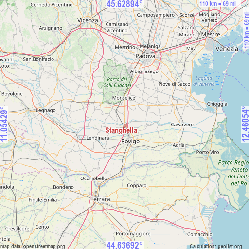
Stanghella GPS coordinates[2]
45° 8' 6.324" North, 11° 45' 26.676" East
| Map corner | latitude | longitude |
|---|---|---|
| Upper-left | 45.62894°, | 11.05429° |
| Center: | 45.13509°, | 11.75741° |
| Lower-right: | 44.63692°, | 12.46054° |
| Map W x H: | 110.3×110.3 km | = 68.5×68.5mi |
| max Lat: | 47.04031° ⇑36.7% North |
| Stanghella: | 45.13509° |
| min Lat: | ⇓63.3% South 35.50142° |
| min Long | Stanghella | max Long |
| 6.69888° | 11.75741° | 18.48682° |
| W 52.5%⇐ | ⇒47.5% E |
Elevation
Elevation of Stanghella is 9 m = 30 ft, and this is 297.7 m = 977 ft below average elevation for this country.
| Max E: |
2085 m = 6841 ft | 94.8% |
| Avg. | 306.7 m = 1006 ft | |
| Stanghella | 9 m = 30 ft | |
Min E: |
-4 m = -13 ft | 5.2% |
See also: Italy elevation on elevation.city.
Geographical zone
Stanghella is located in North temperate zone (between Tropic of Cancer and the Arctic Circle). Distance of this North polar circle is 2382.6 km =1480.5 mi to North.| Distance of | km | miles | from Stanghella |
|---|---|---|---|
| North Pole | 4988.5 | 3099.7 | to North |
| Arctic Circle | 2382.6 | 1480.5 | to North |
| Tropic Cancer | 2412.6 | 1499.1 | to South |
| Equator | 5018.6 | 3118.4 | to South |


Nearby cities:
15 places around Stanghella: (largest is in red/bold)
• Barbona
5.4 km =3.4 mi,  229°
229°
• Boara Pisani
3.6 km =2.2 mi,  146°
146°
• Carmignano
8.8 km =5.5 mi,  281°
281°
• Concadirame
5.1 km =3.2 mi,  205°
205°
• Granze
4.1 km =2.5 mi,  305°
305°
• Lusia
8.3 km =5.2 mi,  240°
240°
• Mardimago
7 km =4.3 mi,  116°
116°
• Pisana
4 km =2.5 mi,  355°
355°
• Pozzonovo
7.3 km =4.5 mi,  21°
21°
• Rovigo
7.7 km =4.8 mi,  160°
160°
• San Martino di Venezze
8.9 km =5.5 mi,  97°
97°
• Sant'Elena
6.8 km =4.2 mi,  328°
328°
• Solesino
5 km =3.1 mi,  350°
350°
• Vescovana
3.5 km =2.2 mi,  268°
268°
• Villa Estense
8.1 km =5 mi,  302°
302°
Sources, notices
• [Note1] Compared only with cities in Italy existing in our database
• [Src1] Map data: © OpenStreetMap contributors (CC-BY-SA)
• [Src2] Other city data from geonames.org with taken over terms of usage.
• [Src3] Geographical zone / Annual Mean Temperature by Robert A. Rohde @ Wikipedia
