Sant'Agnello geodata
Sant'Agnello (Campania) is a seat of a third-order administrative division; located in Italy in Europe/Rome (GMT+2) time zone. With population of 7,674 people, there are 1267 cities with bigger population in this country. Compared to other cities in Italy, 83.2% of cities are located further ↑North; 81.8% of cities are located further ←West and 74% of cities have higher elevation than Sant'Agnello. Note1


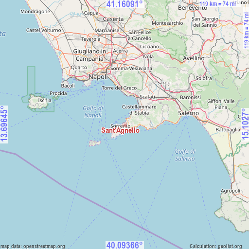
Sant'Agnello GPS coordinates[2]
40° 37' 45.912" North, 14° 23' 58.452" East
| Map corner | latitude | longitude |
|---|---|---|
| Upper-left | 41.16091°, | 13.69645° |
| Center: | 40.62942°, | 14.39957° |
| Lower-right: | 40.09366°, | 15.1027° |
| Map W x H: | 118.7×118.7 km | = 73.8×73.8mi |
| max Lat: | 47.04031° ⇑83.2% North |
| Sant'Agnello: | 40.62942° |
| min Lat: | ⇓16.8% South 35.50142° |
| min Long | Sant'Agnello | max Long |
| 6.69888° | 14.39957° | 18.48682° |
| W 81.8%⇐ | ⇒18.2% E |
Elevation
Elevation of Sant'Agnello is 78 m = 256 ft, and this is 228.7 m = 750 ft below average elevation for this country.
| Max E: |
2085 m = 6841 ft | 74% |
| Avg. | 306.7 m = 1006 ft | |
| Sant'Agnello | 78 m = 256 ft | |
Min E: |
-4 m = -13 ft | 26% |
See also: Italy elevation on elevation.city.
Geographical zone
Sant'Agnello is located in North temperate zone (between Tropic of Cancer and the Arctic Circle). Distance of this Northern Tropic circle is 1911.6 km =1187.8 mi to South.| Distance of | km | miles | from Sant'Agnello |
|---|---|---|---|
| North Pole | 5489.5 | 3411 | to North |
| Arctic Circle | 2883.6 | 1791.8 | to North |
| Tropic Cancer | 1911.6 | 1187.8 | to South |
| Equator | 4517.6 | 2807.1 | to South |


Nearby cities:
15 places around Sant'Agnello: (largest is in red/bold)
• Arola-Preazzano
2.9 km =1.8 mi,  81°
81°
• Massa Lubrense
3.2 km =2 mi,  226°
226°
• Meta
1.9 km =1.2 mi,  47°
47°
• Moiano
6.1 km =3.8 mi,  66°
66°
• Montechiaro
2.9 km =1.8 mi,  17°
17°
• Montepertuso
7.9 km =4.9 mi,  87°
87°
• Patierno
5.4 km =3.4 mi, 54°
• Piano di Sorrento
1.5 km =0.9 mi,  95°
95°
• Positano
7.1 km =4.4 mi, 91°
• Priora
3 km =1.9 mi,  244°
244°
• Sant'Agata sui Due Golfi
3.4 km =2.1 mi,  219°
219°
• Sorrento
1.9 km =1.2 mi,  260°
260°
• Termini
6.8 km =4.2 mi, 229°
• Ticciano
4.9 km =3 mi, 68°
• Vico Equense
4.4 km =2.7 mi,  40°
40°
Sources, notices
• [Note1] Compared only with cities in Italy existing in our database
• [Src1] Map data: © OpenStreetMap contributors (CC-BY-SA)
• [Src2] Other city data from geonames.org with taken over terms of usage.
• [Src3] Geographical zone / Annual Mean Temperature by Robert A. Rohde @ Wikipedia
