Arola-Preazzano geodata
Arola-Preazzano (Campania) is a populated place; located in Italy in Europe/Rome (GMT+2) time zone. With population of 2,583 people, there are 3430 cities with bigger population in this country. Compared to other cities in Italy, 83.1% of cities are located further ↑North; 82% of cities are located further ←West and 66.7% of cities have lower elevation than Arola-Preazzano. Note1


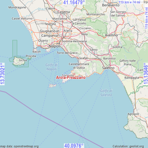
Arola-Preazzano GPS coordinates[2]
40° 37' 59.988" North, 14° 25' 59.988" East
| Map corner | latitude | longitude |
|---|---|---|
| Upper-left | 41.16479°, | 13.73021° |
| Center: | 40.63333°, | 14.43333° |
| Lower-right: | 40.0976°, | 15.13646° |
| Map W x H: | 118.7×118.7 km | = 73.8×73.8mi |
| max Lat: | 47.04031° ⇑83.1% North |
| Arola-Preazzano: | 40.63333° |
| min Lat: | ⇓16.9% South 35.50142° |
| min Long | Arola-Preazzano | max Long |
| 6.69888° | 14.43333° | 18.48682° |
| W 82%⇐ | ⇒18% E |
Elevation
Elevation of Arola-Preazzano is 360 m = 1181 ft, and this is 53.3 m = 175 ft above average elevation for this country.
| Max E: |
2085 m = 6841 ft | 33.3% |
| Arola-Preazzano | 360 m 1181 ft | |
| Avg. | 306.7 m = 1006 ft | |
Min E: |
-4 m = -13 ft | 66.7% |
See also: Italy elevation on elevation.city.
Geographical zone
Arola-Preazzano is located in North temperate zone (between Tropic of Cancer and the Arctic Circle). Distance of this Northern Tropic circle is 1912.1 km =1188.1 mi to South.| Distance of | km | miles | from Arola-Preazzano |
|---|---|---|---|
| North Pole | 5489.1 | 3410.8 | to North |
| Arctic Circle | 2883.2 | 1791.5 | to North |
| Tropic Cancer | 1912.1 | 1188.1 | to South |
| Equator | 4518 | 2807.4 | to South |


Nearby cities:
15 places around Arola-Preazzano: (largest is in red/bold)
• Massa Lubrense
5.8 km =3.6 mi,  242°
242°
• Meta
1.7 km =1.1 mi,  299°
299°
• Moiano
3.4 km =2.1 mi,  53°
53°
• Montechiaro
3 km =1.9 mi,  319°
319°
• Montepertuso
5 km =3.1 mi,  91°
91°
• Patierno
3.1 km =1.9 mi,  29°
29°
• Piano di Sorrento
1.5 km =0.9 mi,  246°
246°
• Piazza-Tralia-Pendolo
7.5 km =4.7 mi, 53°
• Positano
4.3 km =2.7 mi,  97°
97°
• Priora
5.9 km =3.7 mi, 252°
• Sant'Agata sui Due Golfi
5.9 km =3.7 mi, 238°
• Sant'Agnello
2.9 km =1.8 mi,  261°
261°
• Sorrento
4.7 km =2.9 mi, 261°
• Ticciano
2.2 km =1.4 mi, 52°
• Vico Equense
2.9 km =1.8 mi,  0°
0°
Sources, notices
• [Note1] Compared only with cities in Italy existing in our database
• [Src1] Map data: © OpenStreetMap contributors (CC-BY-SA)
• [Src2] Other city data from geonames.org with taken over terms of usage.
• [Src3] Geographical zone / Annual Mean Temperature by Robert A. Rohde @ Wikipedia
