Montepertuso geodata
Montepertuso (Campania) is a populated place; located in Italy in Europe/Rome (GMT+2) time zone. With population of 702 people, there are 8285 cities with bigger population in this country. Compared to other cities in Italy, 83.2% of cities are located further ↑North; 82.6% of cities are located further ←West and 64.3% of cities have lower elevation than Montepertuso. Note1


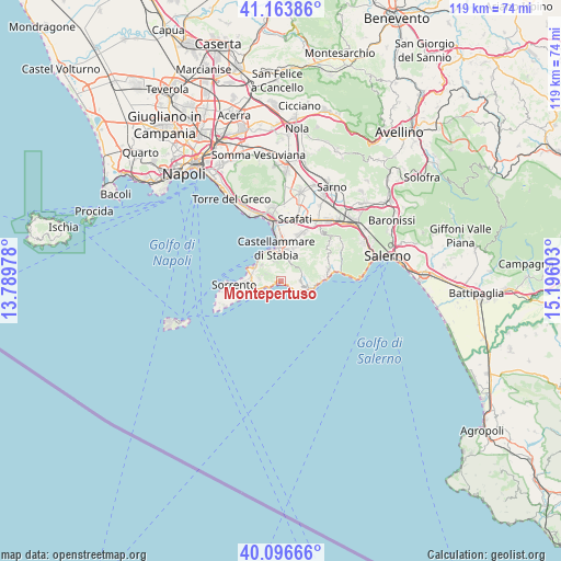
Montepertuso GPS coordinates[2]
40° 37' 56.604" North, 14° 29' 34.44" East
| Map corner | latitude | longitude |
|---|---|---|
| Upper-left | 41.16386°, | 13.78978° |
| Center: | 40.63239°, | 14.4929° |
| Lower-right: | 40.09666°, | 15.19603° |
| Map W x H: | 118.7×118.7 km | = 73.8×73.8mi |
| max Lat: | 47.04031° ⇑83.2% North |
| Montepertuso: | 40.63239° |
| min Lat: | ⇓16.8% South 35.50142° |
| min Long | Montepertuso | max Long |
| 6.69888° | 14.4929° | 18.48682° |
| W 82.6%⇐ | ⇒17.4% E |
Elevation
Elevation of Montepertuso is 337 m = 1106 ft, and this is 30.3 m = 99 ft above average elevation for this country.
| Max E: |
2085 m = 6841 ft | 35.7% |
| Montepertuso | 337 m 1106 ft | |
| Avg. | 306.7 m = 1006 ft | |
Min E: |
-4 m = -13 ft | 64.3% |
See also: Italy elevation on elevation.city.
Geographical zone
Montepertuso is located in North temperate zone (between Tropic of Cancer and the Arctic Circle). Distance of this Northern Tropic circle is 1912 km =1188.1 mi to South.| Distance of | km | miles | from Montepertuso |
|---|---|---|---|
| North Pole | 5489.2 | 3410.8 | to North |
| Arctic Circle | 2883.3 | 1791.6 | to North |
| Tropic Cancer | 1912 | 1188.1 | to South |
| Equator | 4517.9 | 2807.3 | to South |


Nearby cities:
15 places around Montepertuso: (largest is in red/bold)
• Agerola
3.9 km =2.4 mi,  81°
81°
• Arola-Preazzano
5 km =3.1 mi,  271°
271°
• Franche
5 km =3.1 mi,  28°
28°
• Furore
4.9 km =3 mi,  105°
105°
• Moiano
3.1 km =1.9 mi,  313°
313°
• Patierno
4.5 km =2.8 mi, 309°
• Pianillo
4.8 km =3 mi,  87°
87°
• Piano di Sorrento
6.4 km =4 mi, 265°
• Piazza-Tralia-Pendolo
4.7 km =2.9 mi,  12°
12°
• Pimonte
4.8 km =3 mi,  17°
17°
• Positano
0.9 km =0.6 mi,  237°
237°
• Praiano
3.5 km =2.2 mi,  130°
130°
• San Michele
5 km =3.1 mi, 105°
• Ticciano
3.6 km =2.2 mi,  293°
293°
• Vico Equense
5.8 km =3.6 mi,  301°
301°
Sources, notices
• [Note1] Compared only with cities in Italy existing in our database
• [Src1] Map data: © OpenStreetMap contributors (CC-BY-SA)
• [Src2] Other city data from geonames.org with taken over terms of usage.
• [Src3] Geographical zone / Annual Mean Temperature by Robert A. Rohde @ Wikipedia
