San Giorgio geodata
San Giorgio (Campania) is a seat of a third-order administrative division; located in Italy in Europe/Rome (GMT+2) time zone. With population of 1,496 people, there are 5125 cities with bigger population in this country. Compared to other cities in Italy, 76.4% of cities are located further ↑North; 81% of cities are located further ←West and 67.8% of cities have higher elevation than San Giorgio. Note1


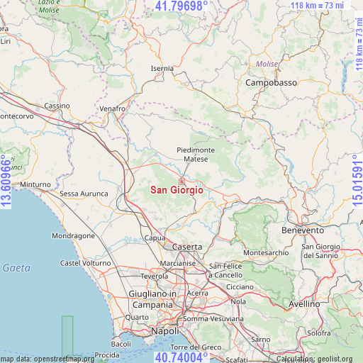
San Giorgio GPS coordinates[2]
41° 16' 14.34" North, 14° 18' 46.008" East
| Map corner | latitude | longitude |
|---|---|---|
| Upper-left | 41.79698°, | 13.60966° |
| Center: | 41.27065°, | 14.31278° |
| Lower-right: | 40.74004°, | 15.01591° |
| Map W x H: | 117.5×117.5 km | = 73×73mi |
| max Lat: | 47.04031° ⇑76.4% North |
| San Giorgio: | 41.27065° |
| min Lat: | ⇓23.6% South 35.50142° |
| min Long | San Giorgio | max Long |
| 6.69888° | 14.31278° | 18.48682° |
| W 81%⇐ | ⇒19% E |
Elevation
Elevation of San Giorgio is 110 m = 361 ft, and this is 196.7 m = 645 ft below average elevation for this country.
| Max E: |
2085 m = 6841 ft | 67.8% |
| Avg. | 306.7 m = 1006 ft | |
| San Giorgio | 110 m = 361 ft | |
Min E: |
-4 m = -13 ft | 32.2% |
See also: Italy elevation on elevation.city.
Geographical zone
San Giorgio is located in North temperate zone (between Tropic of Cancer and the Arctic Circle). Distance of this Northern Tropic circle is 1982.9 km =1232.1 mi to South.| Distance of | km | miles | from San Giorgio |
|---|---|---|---|
| North Pole | 5418.2 | 3366.7 | to North |
| Arctic Circle | 2812.3 | 1747.5 | to North |
| Tropic Cancer | 1982.9 | 1232.1 | to South |
| Equator | 4588.9 | 2851.4 | to South |


Nearby cities:
15 places around San Giorgio: (largest is in red/bold)
• Alife
6.4 km =4 mi,  16°
16°
• Alvignano
3.6 km =2.2 mi,  145°
145°
• Baia
6.4 km =4 mi,  305°
305°
• Caiazzo
10.4 km =6.5 mi,  157°
157°
• Castel di Sasso
9.2 km =5.7 mi,  198°
198°
• Dragoni
1 km =0.6 mi, 309°
• Formicola
9.3 km =5.8 mi,  224°
224°
• Latina
4 km =2.5 mi,  302°
302°
• Liberi
5.3 km =3.3 mi, 201°
• Piedimonte Matese
10 km =6.2 mi,  27°
27°
• Pietramelara
10.5 km =6.5 mi,  270°
270°
• Pontelatone
10 km =6.2 mi,  212°
212°
• Roccaromana
7.6 km =4.7 mi, 272°
• Ruviano
10.5 km =6.5 mi,  129°
129°
• San Potito Sannitico
9.9 km =6.2 mi,  41°
41°
Sources, notices
• [Note1] Compared only with cities in Italy existing in our database
• [Src1] Map data: © OpenStreetMap contributors (CC-BY-SA)
• [Src2] Other city data from geonames.org with taken over terms of usage.
• [Src3] Geographical zone / Annual Mean Temperature by Robert A. Rohde @ Wikipedia
