Ruviano geodata
Ruviano (Campania) is a seat of a third-order administrative division; located in Italy in Europe/Rome (GMT+2) time zone. With population of 317 people, there are 10606 cities with bigger population in this country. Compared to other cities in Italy, 76.8% of cities are located further ↑North; 81.9% of cities are located further ←West and 75.9% of cities have higher elevation than Ruviano. Note1


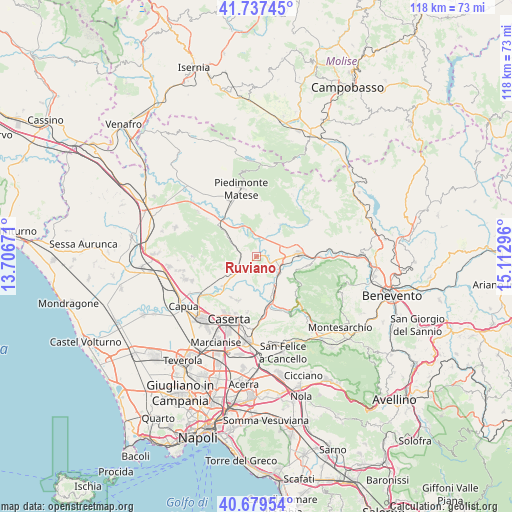
Ruviano GPS coordinates[2]
41° 12' 38.268" North, 14° 24' 35.388" East
| Map corner | latitude | longitude |
|---|---|---|
| Upper-left | 41.73745°, | 13.70671° |
| Center: | 41.21063°, | 14.40983° |
| Lower-right: | 40.67954°, | 15.11296° |
| Map W x H: | 117.6×117.6 km | = 73.1×73.1mi |
| max Lat: | 47.04031° ⇑76.8% North |
| Ruviano: | 41.21063° |
| min Lat: | ⇓23.2% South 35.50142° |
| min Long | Ruviano | max Long |
| 6.69888° | 14.40983° | 18.48682° |
| W 81.9%⇐ | ⇒18.1% E |
Elevation
Elevation of Ruviano is 70 m = 230 ft, and this is 236.7 m = 777 ft below average elevation for this country.
| Max E: |
2085 m = 6841 ft | 75.9% |
| Avg. | 306.7 m = 1006 ft | |
| Ruviano | 70 m = 230 ft | |
Min E: |
-4 m = -13 ft | 24.1% |
See also: Italy elevation on elevation.city.
Geographical zone
Ruviano is located in North temperate zone (between Tropic of Cancer and the Arctic Circle). Distance of this Northern Tropic circle is 1976.3 km =1228 mi to South.| Distance of | km | miles | from Ruviano |
|---|---|---|---|
| North Pole | 5424.9 | 3370.9 | to North |
| Arctic Circle | 2819 | 1751.6 | to North |
| Tropic Cancer | 1976.3 | 1228 | to South |
| Equator | 4582.2 | 2847.2 | to South |


Nearby cities:
15 places around Ruviano: (largest is in red/bold)
• Alvignano
7.2 km =4.5 mi,  301°
301°
• Amorosi
4.8 km =3 mi,  100°
100°
• Caiazzo
5.1 km =3.2 mi,  235°
235°
• Castel Campagnano
4.8 km =3 mi,  130°
130°
• Dugenta
9.2 km =5.7 mi,  156°
156°
• Faicchio
9.4 km =5.8 mi,  36°
36°
• Limatola
7.9 km =4.9 mi,  189°
189°
• Melizzano
9.7 km =6 mi,  124°
124°
• Piana di Monte Verna
8 km =5 mi,  232°
232°
• Puglianello
3.6 km =2.2 mi,  69°
69°
• San Giovanni e Paolo
4.3 km =2.7 mi,  205°
205°
• San Salvatore Telesino
7.9 km =4.9 mi, 69°
• Telese
9.8 km =6.1 mi,  85°
85°
• Via Fausto Coppi
9.9 km =6.2 mi, 90°
• Via S. Giovanni
8.5 km =5.3 mi, 87°
Sources, notices
• [Note1] Compared only with cities in Italy existing in our database
• [Src1] Map data: © OpenStreetMap contributors (CC-BY-SA)
• [Src2] Other city data from geonames.org with taken over terms of usage.
• [Src3] Geographical zone / Annual Mean Temperature by Robert A. Rohde @ Wikipedia
