Baia geodata
Baia (Campania) is a seat of a third-order administrative division; located in Italy in Europe/Rome (GMT+2) time zone. With population of 1,145 people, there are 6129 cities with bigger population in this country. Compared to other cities in Italy, 76.1% of cities are located further ↑North; 80.3% of cities are located further ←West and 67.4% of cities have higher elevation than Baia. Note1


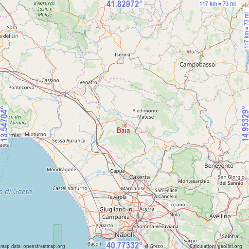
Baia GPS coordinates[2]
41° 18' 13.176" North, 14° 15' 0.576" East
| Map corner | latitude | longitude |
|---|---|---|
| Upper-left | 41.82972°, | 13.54704° |
| Center: | 41.30366°, | 14.25016° |
| Lower-right: | 40.77332°, | 14.95329° |
| Map W x H: | 117.5×117.5 km | = 73×73mi |
| max Lat: | 47.04031° ⇑76.1% North |
| Baia: | 41.30366° |
| min Lat: | ⇓23.9% South 35.50142° |
| min Long | Baia | max Long |
| 6.69888° | 14.25016° | 18.48682° |
| W 80.3%⇐ | ⇒19.7% E |
Elevation
Elevation of Baia is 113 m = 371 ft, and this is 193.7 m = 635 ft below average elevation for this country.
| Max E: |
2085 m = 6841 ft | 67.4% |
| Avg. | 306.7 m = 1006 ft | |
| Baia | 113 m = 371 ft | |
Min E: |
-4 m = -13 ft | 32.6% |
See also: Italy elevation on elevation.city.
Geographical zone
Baia is located in North temperate zone (between Tropic of Cancer and the Arctic Circle). Distance of this Northern Tropic circle is 1986.6 km =1234.4 mi to South.| Distance of | km | miles | from Baia |
|---|---|---|---|
| North Pole | 5414.5 | 3364.4 | to North |
| Arctic Circle | 2808.6 | 1745.2 | to North |
| Tropic Cancer | 1986.6 | 1234.4 | to South |
| Equator | 4592.5 | 2853.6 | to South |


Nearby cities:
15 places around Baia: (largest is in red/bold)
• Ailano
10.3 km =6.4 mi,  338°
338°
• Alife
7.4 km =4.6 mi,  70°
70°
• Alvignano
9.8 km =6.1 mi,  132°
132°
• Dragoni
5.4 km =3.4 mi,  124°
124°
• Formicola
10.4 km =6.5 mi,  187°
187°
• Latina
2.4 km =1.5 mi, 129°
• Liberi
9.2 km =5.7 mi,  158°
158°
• Pietramelara
6.4 km =4 mi,  235°
235°
• Pietravairano
7.4 km =4.6 mi,  288°
288°
• Raviscanina
7.5 km =4.7 mi,  355°
355°
• Riardo
9.5 km =5.9 mi, 240°
• Roccaromana
4.1 km =2.5 mi,  215°
215°
• San Giorgio
6.4 km =4 mi, 125°
• Sant'Angelo d'Alife
6.5 km =4 mi,  8°
8°
• Vairano-Patenora
10.6 km =6.6 mi, 290°
Sources, notices
• [Note1] Compared only with cities in Italy existing in our database
• [Src1] Map data: © OpenStreetMap contributors (CC-BY-SA)
• [Src2] Other city data from geonames.org with taken over terms of usage.
• [Src3] Geographical zone / Annual Mean Temperature by Robert A. Rohde @ Wikipedia
