Sangano geodata
Sangano (Piedmont) is a seat of a third-order administrative division; located in Italy in Europe/Rome (GMT+2) time zone. With population of 3,459 people, there are 2711 cities with bigger population in this country. Compared to other cities in Italy, 60.6% of cities are located further ↓South; 98.1% of cities are located further →East and 64.7% of cities have lower elevation than Sangano. Note1


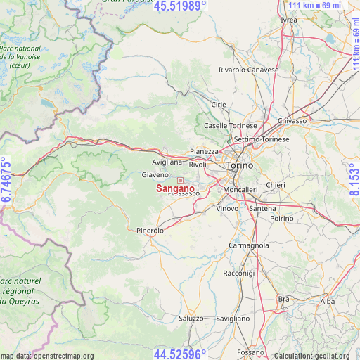
Sangano GPS coordinates[2]
45° 1' 30.288" North, 7° 26' 59.532" East
| Map corner | latitude | longitude |
|---|---|---|
| Upper-left | 45.51989°, | 6.74675° |
| Center: | 45.02508°, | 7.44987° |
| Lower-right: | 44.52596°, | 8.153° |
| Map W x H: | 110.5×110.5 km | = 68.7×68.7mi |
| max Lat: | 47.04031° ⇑39.4% North |
| Sangano: | 45.02508° |
| min Lat: | ⇓60.6% South 35.50142° |
| min Long | Sangano | max Long |
| 6.69888° | 7.44987° | 18.48682° |
| W 1.9%⇐ | ⇒98.1% E |
Elevation
Elevation of Sangano is 340 m = 1115 ft, and this is 33.3 m = 109 ft above average elevation for this country.
| Max E: |
2085 m = 6841 ft | 35.3% |
| Sangano | 340 m 1115 ft | |
| Avg. | 306.7 m = 1006 ft | |
Min E: |
-4 m = -13 ft | 64.7% |
See also: Italy elevation on elevation.city.
Geographical zone
Sangano is located in North temperate zone (between Tropic of Cancer and the Arctic Circle). Distance of this North polar circle is 2394.9 km =1488.1 mi to North.| Distance of | km | miles | from Sangano |
|---|---|---|---|
| North Pole | 5000.7 | 3107.3 | to North |
| Arctic Circle | 2394.9 | 1488.1 | to North |
| Tropic Cancer | 2400.4 | 1491.5 | to South |
| Equator | 5006.3 | 3110.8 | to South |


Nearby cities:
15 places around Sangano: (largest is in red/bold)
• Bruino
2.4 km =1.5 mi,  117°
117°
• Buttigliera Alta
5 km =3.1 mi,  344°
344°
• Corbiglia
4.3 km =2.7 mi,  52°
52°
• Ferriera
6.7 km =4.2 mi,  346°
346°
• Gerbole
5.2 km =3.2 mi, 120°
• Gerbole-Zucche
6.8 km =4.2 mi,  129°
129°
• Orbassano
7.3 km =4.5 mi,  107°
107°
• Piossasco
4.2 km =2.6 mi,  168°
168°
• Reano
3.5 km =2.2 mi,  330°
330°
• Rivalta di Torino
5.6 km =3.5 mi,  81°
81°
• Rivoli
7.2 km =4.5 mi, 45°
• Rosta
4.9 km =3 mi,  14°
14°
• San Bernardino
4.3 km =2.7 mi,  286°
286°
• Trana
2.7 km =1.7 mi,  303°
303°
• Villarbasse
2.7 km =1.7 mi,  33°
33°
Sources, notices
• [Note1] Compared only with cities in Italy existing in our database
• [Src1] Map data: © OpenStreetMap contributors (CC-BY-SA)
• [Src2] Other city data from geonames.org with taken over terms of usage.
• [Src3] Geographical zone / Annual Mean Temperature by Robert A. Rohde @ Wikipedia
