Gerbole-Zucche geodata
Gerbole-Zucche (Piedmont) is a populated place; located in Italy in Europe/Rome (GMT+2) time zone. With population of 2,645 people, there are 3375 cities with bigger population in this country. Compared to other cities in Italy, 59.6% of cities are located further ↓South; 97.7% of cities are located further →East and 55.7% of cities have lower elevation than Gerbole-Zucche. Note1


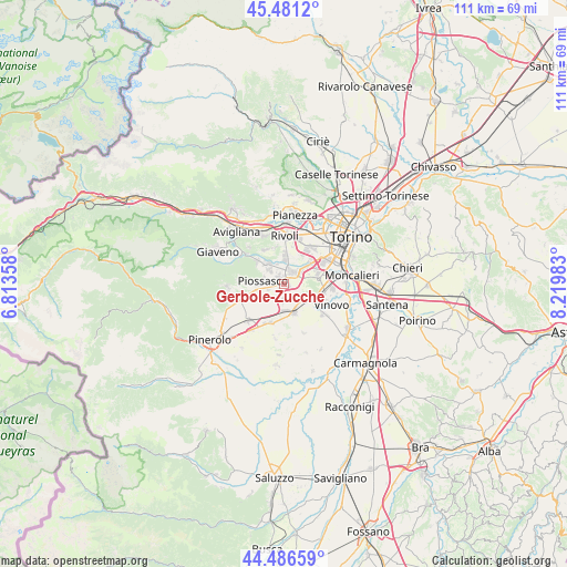
Gerbole-Zucche GPS coordinates[2]
44° 59' 9.78" North, 7° 31' 0.156" East
| Map corner | latitude | longitude |
|---|---|---|
| Upper-left | 45.4812°, | 6.81358° |
| Center: | 44.98605°, | 7.51671° |
| Lower-right: | 44.48659°, | 8.21983° |
| Map W x H: | 110.6×110.6 km | = 68.7×68.7mi |
| max Lat: | 47.04031° ⇑40.4% North |
| Gerbole-Zucche: | 44.98605° |
| min Lat: | ⇓59.6% South 35.50142° |
| min Long | Gerbole-Zucche | max Long |
| 6.69888° | 7.51671° | 18.48682° |
| W 2.3%⇐ | ⇒97.7% E |
Elevation
Elevation of Gerbole-Zucche is 270 m = 886 ft, and this is 36.7 m = 120 ft below average elevation for this country.
| Max E: |
2085 m = 6841 ft | 44.3% |
| Avg. | 306.7 m = 1006 ft | |
| Gerbole-Zucche | 270 m = 886 ft | |
Min E: |
-4 m = -13 ft | 55.7% |
See also: Italy elevation on elevation.city.
Geographical zone
Gerbole-Zucche is located in North temperate zone (between Tropic of Cancer and the Arctic Circle). Distance of this Northern Tropic circle is 2396.1 km =1488.9 mi to South.| Distance of | km | miles | from Gerbole-Zucche |
|---|---|---|---|
| North Pole | 5005.1 | 3110 | to North |
| Arctic Circle | 2399.2 | 1490.8 | to North |
| Tropic Cancer | 2396.1 | 1488.9 | to South |
| Equator | 5002 | 3108.1 | to South |


Nearby cities:
15 places around Gerbole-Zucche: (largest is in red/bold)
• Beinasco
6.9 km =4.3 mi,  51°
51°
• Borgo Melano
5.8 km =3.6 mi, 54°
• Bruino
4.5 km =2.8 mi,  316°
316°
• Candiolo
7.1 km =4.4 mi,  115°
115°
• Corbiglia
7.2 km =4.5 mi,  345°
345°
• Gerbole
1.9 km =1.2 mi,  334°
334°
• None
5.8 km =3.6 mi,  161°
161°
• Orbassano
2.7 km =1.7 mi,  37°
37°
• Pasta
4 km =2.5 mi, 44°
• Piossasco
4.5 km =2.8 mi,  272°
272°
• Rivalta di Torino
5.2 km =3.2 mi,  3°
3°
• Sangano
6.8 km =4.2 mi,  309°
309°
• Tetti Neirotti
7.7 km =4.8 mi,  14°
14°
• Villarbasse
7.6 km =4.7 mi, 329°
• Volvera
3.5 km =2.2 mi,  186°
186°
Sources, notices
• [Note1] Compared only with cities in Italy existing in our database
• [Src1] Map data: © OpenStreetMap contributors (CC-BY-SA)
• [Src2] Other city data from geonames.org with taken over terms of usage.
• [Src3] Geographical zone / Annual Mean Temperature by Robert A. Rohde @ Wikipedia
