Corbiglia geodata
Corbiglia (Piedmont) is a populated place; located in Italy in Europe/Rome (GMT+2) time zone. With population of 565 people, there are 9298 cities with bigger population in this country. Compared to other cities in Italy, 61.1% of cities are located further ↓South; 97.8% of cities are located further →East and 65.9% of cities have lower elevation than Corbiglia. Note1


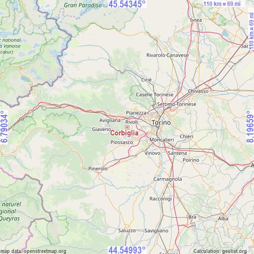
Corbiglia GPS coordinates[2]
45° 2' 55.86" North, 7° 29' 36.456" East
| Map corner | latitude | longitude |
|---|---|---|
| Upper-left | 45.54345°, | 6.79034° |
| Center: | 45.04885°, | 7.49346° |
| Lower-right: | 44.54993°, | 8.19659° |
| Map W x H: | 110.5×110.5 km | = 68.7×68.7mi |
| max Lat: | 47.04031° ⇑38.9% North |
| Corbiglia: | 45.04885° |
| min Lat: | ⇓61.1% South 35.50142° |
| min Long | Corbiglia | max Long |
| 6.69888° | 7.49346° | 18.48682° |
| W 2.2%⇐ | ⇒97.8% E |
Elevation
Elevation of Corbiglia is 352 m = 1155 ft, and this is 45.3 m = 149 ft above average elevation for this country.
| Max E: |
2085 m = 6841 ft | 34.1% |
| Corbiglia | 352 m 1155 ft | |
| Avg. | 306.7 m = 1006 ft | |
Min E: |
-4 m = -13 ft | 65.9% |
See also: Italy elevation on elevation.city.
Geographical zone
Corbiglia is located in North temperate zone (between Tropic of Cancer and the Arctic Circle). Distance of this North polar circle is 2392.2 km =1486.4 mi to North.| Distance of | km | miles | from Corbiglia |
|---|---|---|---|
| North Pole | 4998.1 | 3105.7 | to North |
| Arctic Circle | 2392.2 | 1486.4 | to North |
| Tropic Cancer | 2403 | 1493.2 | to South |
| Equator | 5009 | 3112.4 | to South |


Nearby cities:
15 places around Corbiglia: (largest is in red/bold)
• Alpignano
5.5 km =3.4 mi,  25°
25°
• Bruino
4 km =2.5 mi,  198°
198°
• Buttigliera Alta
5.3 km =3.3 mi,  294°
294°
• Ferriera
6.3 km =3.9 mi,  308°
308°
• Gerbole
5.4 km =3.4 mi,  168°
168°
• Orbassano
6 km =3.7 mi,  143°
143°
• Pasta
6.2 km =3.9 mi,  132°
132°
• Reano
5.2 km =3.2 mi,  274°
274°
• Rivalta di Torino
2.8 km =1.7 mi, 130°
• Rivoli
2.9 km =1.8 mi, 34°
• Rosta
3.1 km =1.9 mi, 313°
• Sangano
4.3 km =2.7 mi,  232°
232°
• Tetti Neirotti
3.8 km =2.4 mi,  82°
82°
• Trana
5.8 km =3.6 mi,  258°
258°
• Villarbasse
2 km =1.2 mi, 258°
Sources, notices
• [Note1] Compared only with cities in Italy existing in our database
• [Src1] Map data: © OpenStreetMap contributors (CC-BY-SA)
• [Src2] Other city data from geonames.org with taken over terms of usage.
• [Src3] Geographical zone / Annual Mean Temperature by Robert A. Rohde @ Wikipedia
