Salento geodata
Salento (Campania) is a seat of a third-order administrative division; located in Italy in Europe/Rome (GMT+2) time zone. With population of 760 people, there are 7881 cities with bigger population in this country. Compared to other cities in Italy, 86.1% of cities are located further ↑North; 88.8% of cities are located further ←West and 72.4% of cities have lower elevation than Salento. Note1


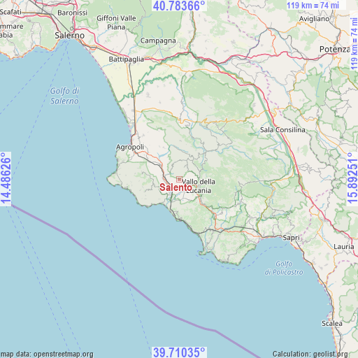
Salento GPS coordinates[2]
40° 14' 56.868" North, 15° 11' 21.768" East
| Map corner | latitude | longitude |
|---|---|---|
| Upper-left | 40.78366°, | 14.48626° |
| Center: | 40.24913°, | 15.18938° |
| Lower-right: | 39.71035°, | 15.89251° |
| Map W x H: | 119.3×119.3 km | = 74.1×74.1mi |
| max Lat: | 47.04031° ⇑86.1% North |
| Salento: | 40.24913° |
| min Lat: | ⇓13.9% South 35.50142° |
| min Long | Salento | max Long |
| 6.69888° | 15.18938° | 18.48682° |
| W 88.8%⇐ | ⇒11.2% E |
Elevation
Elevation of Salento is 419 m = 1375 ft, and this is 112.3 m = 368 ft above average elevation for this country.
| Max E: |
2085 m = 6841 ft | 27.6% |
| Salento | 419 m 1375 ft | |
| Avg. | 306.7 m = 1006 ft | |
Min E: |
-4 m = -13 ft | 72.4% |
See also: Italy elevation on elevation.city.
Geographical zone
Salento is located in North temperate zone (between Tropic of Cancer and the Arctic Circle). Distance of this Northern Tropic circle is 1869.4 km =1161.6 mi to South.| Distance of | km | miles | from Salento |
|---|---|---|---|
| North Pole | 5531.8 | 3437.3 | to North |
| Arctic Circle | 2925.9 | 1818.1 | to North |
| Tropic Cancer | 1869.4 | 1161.6 | to South |
| Equator | 4475.3 | 2780.8 | to South |


Nearby cities:
15 places around Salento: (largest is in red/bold)
• Acquavella
7.5 km =4.7 mi,  233°
233°
• Bivio Acquavella-Ponte
6.5 km =4 mi,  215°
215°
• Cardile
5.2 km =3.2 mi,  63°
63°
• Castelnuovo Cilento
3.5 km =2.2 mi,  195°
195°
• Ceraso
8.3 km =5.2 mi,  137°
137°
• Fasana
4.3 km =2.7 mi,  271°
271°
• Gioi
5.1 km =3.2 mi,  28°
28°
• Moio della Civitella-Pellare
6.7 km =4.2 mi,  91°
91°
• Omignano Scalo
4.8 km =3 mi, 271°
• Orria
5.8 km =3.6 mi,  344°
344°
• Perito
6.5 km =4 mi,  327°
327°
• Salicuneta
5.7 km =3.5 mi,  193°
193°
• Stella Cilento
8.4 km =5.2 mi,  256°
256°
• Vallo della Lucania
6.9 km =4.3 mi,  109°
109°
• Velina
5.8 km =3.6 mi,  205°
205°
Sources, notices
• [Note1] Compared only with cities in Italy existing in our database
• [Src1] Map data: © OpenStreetMap contributors (CC-BY-SA)
• [Src2] Other city data from geonames.org with taken over terms of usage.
• [Src3] Geographical zone / Annual Mean Temperature by Robert A. Rohde @ Wikipedia
