Velina geodata
Velina (Campania) is a populated place; located in Italy in Europe/Rome (GMT+2) time zone. With population of 942 people, there are 6911 cities with bigger population in this country. Compared to other cities in Italy, 86.4% of cities are located further ↑North; 88.5% of cities are located further ←West and 92.1% of cities have higher elevation than Velina. Note1
Administrative division(s):
- Level 1: Campania
- Level 2: Provincia di Salerno
- Level 3: Castelnuovo Cilento


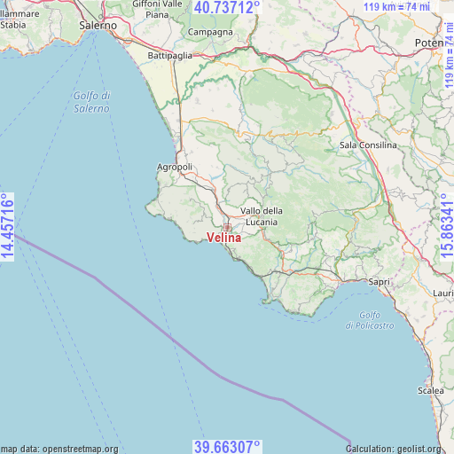
Velina GPS coordinates[2]
40° 12' 7.992" North, 15° 9' 37.008" East
| Map corner | latitude | longitude |
|---|---|---|
| Upper-left | 40.73712°, | 14.45716° |
| Center: | 40.20222°, | 15.16028° |
| Lower-right: | 39.66307°, | 15.86341° |
| Map W x H: | 119.4×119.4 km | = 74.2×74.2mi |
| max Lat: | 47.04031° ⇑86.4% North |
| Velina: | 40.20222° |
| min Lat: | ⇓13.6% South 35.50142° |
| min Long | Velina | max Long |
| 6.69888° | 15.16028° | 18.48682° |
| W 88.5%⇐ | ⇒11.5% E |
Elevation
Elevation of Velina is 14 m = 46 ft, and this is 292.7 m = 960 ft below average elevation for this country.
| Max E: |
2085 m = 6841 ft | 92.1% |
| Avg. | 306.7 m = 1006 ft | |
| Velina | 14 m = 46 ft | |
Min E: |
-4 m = -13 ft | 7.9% |
See also: Italy elevation on elevation.city.
Geographical zone
Velina is located in North temperate zone (between Tropic of Cancer and the Arctic Circle). Distance of this Northern Tropic circle is 1864.1 km =1158.3 mi to South.| Distance of | km | miles | from Velina |
|---|---|---|---|
| North Pole | 5537 | 3440.5 | to North |
| Arctic Circle | 2931.1 | 1821.3 | to North |
| Tropic Cancer | 1864.1 | 1158.3 | to South |
| Equator | 4470.1 | 2777.6 | to South |


Nearby cities:
15 places around Velina: (largest is in red/bold)
• Acquavella
3.7 km =2.3 mi,  282°
282°
• Ascea
7.2 km =4.5 mi,  162°
162°
• Bivio Acquavella-Ponte
1.3 km =0.8 mi,  268°
268°
• Casal Velino
4.4 km =2.7 mi,  252°
252°
• Castelnuovo Cilento
2.4 km =1.5 mi,  39°
39°
• Ceraso
8.2 km =5.1 mi,  96°
96°
• Fasana
5.6 km =3.5 mi,  340°
340°
• Marina di Casal Velino
4.3 km =2.7 mi,  228°
228°
• Omignano
8.3 km =5.2 mi,  308°
308°
• Omignano Scalo
5.8 km =3.6 mi, 336°
• Pollica
8.9 km =5.5 mi,  261°
261°
• Salento
5.8 km =3.6 mi,  25°
25°
• Salicuneta
1.2 km =0.7 mi, 104°
• Santa Barbara
8.7 km =5.4 mi,  107°
107°
• Stella Cilento
6.6 km =4.1 mi,  299°
299°
Sources, notices
• [Note1] Compared only with cities in Italy existing in our database
• [Src1] Map data: © OpenStreetMap contributors (CC-BY-SA)
• [Src2] Other city data from geonames.org with taken over terms of usage.
• [Src3] Geographical zone / Annual Mean Temperature by Robert A. Rohde @ Wikipedia
