Sabaudia geodata
Sabaudia (Latium) is a seat of a third-order administrative division; located in Italy in Europe/Rome (GMT+2) time zone. With population of 8,743 people, there are 1090 cities with bigger population in this country. Compared to other cities in Italy, 76.1% of cities are located further ↑North; 68.6% of cities are located further ←West and 89.6% of cities have higher elevation than Sabaudia. Note1


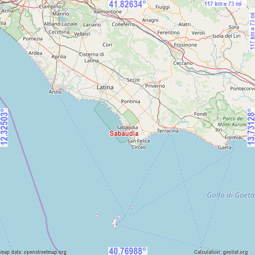
Sabaudia GPS coordinates[2]
41° 18' 0.9" North, 13° 1' 41.34" East
| Map corner | latitude | longitude |
|---|---|---|
| Upper-left | 41.82634°, | 12.32503° |
| Center: | 41.30025°, | 13.02815° |
| Lower-right: | 40.76988°, | 13.73128° |
| Map W x H: | 117.5×117.5 km | = 73×73mi |
| max Lat: | 47.04031° ⇑76.1% North |
| Sabaudia: | 41.30025° |
| min Lat: | ⇓23.9% South 35.50142° |
| min Long | Sabaudia | max Long |
| 6.69888° | 13.02815° | 18.48682° |
| W 68.6%⇐ | ⇒31.4% E |
Elevation
Elevation of Sabaudia is 19 m = 62 ft, and this is 287.7 m = 944 ft below average elevation for this country.
| Max E: |
2085 m = 6841 ft | 89.6% |
| Avg. | 306.7 m = 1006 ft | |
| Sabaudia | 19 m = 62 ft | |
Min E: |
-4 m = -13 ft | 10.4% |
See also: Italy elevation on elevation.city.
Geographical zone
Sabaudia is located in North temperate zone (between Tropic of Cancer and the Arctic Circle). Distance of this Northern Tropic circle is 1986.2 km =1234.2 mi to South.| Distance of | km | miles | from Sabaudia |
|---|---|---|---|
| North Pole | 5414.9 | 3364.7 | to North |
| Arctic Circle | 2809 | 1745.4 | to North |
| Tropic Cancer | 1986.2 | 1234.2 | to South |
| Equator | 4592.2 | 2853.5 | to South |


Nearby cities:
15 places around Sabaudia: (largest is in red/bold)
• Bella Farnia
8.7 km =5.4 mi,  329°
329°
• Borgo Faiti
18.7 km =11.6 mi,  352°
352°
• Borgo Grappa
12.7 km =7.9 mi, 333°
• Borgo Hermada
12.1 km =7.5 mi,  87°
87°
• Borgo San Michele
16 km =9.9 mi,  343°
343°
• Borgo Vodice
7.7 km =4.8 mi,  55°
55°
• Campodimele
9.2 km =5.7 mi,  2°
2°
• La Fiora
14.4 km =8.9 mi,  74°
74°
• Molella
5.3 km =3.3 mi,  147°
147°
• Pontinia
12.4 km =7.7 mi,  5°
5°
• Prato di Coppola
17.9 km =11.1 mi,  316°
316°
• San Donato
10.4 km =6.5 mi, 346°
• San Felice Circeo
8.9 km =5.5 mi,  141°
141°
• Scopeto Madonna Gulia
14.8 km =9.2 mi, 338°
• Terracina
18 km =11.2 mi, 93°
Sources, notices
• [Note1] Compared only with cities in Italy existing in our database
• [Src1] Map data: © OpenStreetMap contributors (CC-BY-SA)
• [Src2] Other city data from geonames.org with taken over terms of usage.
• [Src3] Geographical zone / Annual Mean Temperature by Robert A. Rohde @ Wikipedia
