Borgo Hermada geodata
Borgo Hermada (Latium) is a populated place; located in Italy in Europe/Rome (GMT+2) time zone. With population of 3,037 people, there are 3011 cities with bigger population in this country. Compared to other cities in Italy, 76% of cities are located further ↑North; 70.1% of cities are located further ←West and 96.6% of cities have higher elevation than Borgo Hermada. Note1


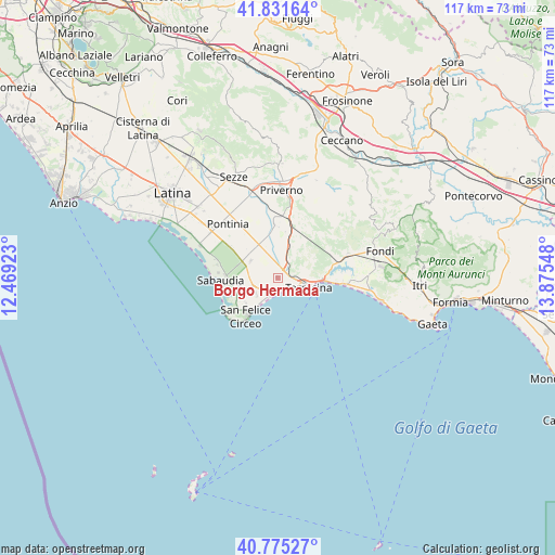
Borgo Hermada GPS coordinates[2]
41° 18' 20.124" North, 13° 10' 20.46" East
| Map corner | latitude | longitude |
|---|---|---|
| Upper-left | 41.83164°, | 12.46923° |
| Center: | 41.30559°, | 13.17235° |
| Lower-right: | 40.77527°, | 13.87548° |
| Map W x H: | 117.5×117.5 km | = 73×73mi |
| max Lat: | 47.04031° ⇑76% North |
| Borgo Hermada: | 41.30559° |
| min Lat: | ⇓24% South 35.50142° |
| min Long | Borgo Hermada | max Long |
| 6.69888° | 13.17235° | 18.48682° |
| W 70.1%⇐ | ⇒29.9% E |
Elevation
Elevation of Borgo Hermada is 6 m = 20 ft, and this is 300.7 m = 987 ft below average elevation for this country.
| Max E: |
2085 m = 6841 ft | 96.6% |
| Avg. | 306.7 m = 1006 ft | |
| Borgo Hermada | 6 m = 20 ft | |
Min E: |
-4 m = -13 ft | 3.4% |
See also: Italy elevation on elevation.city.
Geographical zone
Borgo Hermada is located in North temperate zone (between Tropic of Cancer and the Arctic Circle). Distance of this Northern Tropic circle is 1986.8 km =1234.5 mi to South.| Distance of | km | miles | from Borgo Hermada |
|---|---|---|---|
| North Pole | 5414.3 | 3364.3 | to North |
| Arctic Circle | 2808.4 | 1745.1 | to North |
| Tropic Cancer | 1986.8 | 1234.5 | to South |
| Equator | 4592.8 | 2853.8 | to South |


Nearby cities:
15 places around Borgo Hermada: (largest is in red/bold)
• Bella Farnia
17.8 km =11.1 mi,  292°
292°
• Borgo Vodice
6.9 km =4.3 mi,  303°
303°
• Campodimele
14.5 km =9 mi,  306°
306°
• La Fiora
3.7 km =2.3 mi,  30°
30°
• Molella
10.5 km =6.5 mi,  241°
241°
• Monte San Biagio
15.9 km =9.9 mi,  70°
70°
• Pontinia
16 km =9.9 mi,  317°
317°
• Priverno
18.3 km =11.4 mi,  1°
1°
• Roccasecca dei Volsci
19.5 km =12.1 mi,  9°
9°
• Sabaudia
12.1 km =7.5 mi,  267°
267°
• San Donato
17.4 km =10.8 mi, 303°
• San Felice Circeo
10 km =6.2 mi,  220°
220°
• Scalo
14.3 km =8.9 mi, 9°
• Sonnino
13.8 km =8.6 mi, 26°
• Terracina
6.1 km =3.8 mi,  104°
104°
Sources, notices
• [Note1] Compared only with cities in Italy existing in our database
• [Src1] Map data: © OpenStreetMap contributors (CC-BY-SA)
• [Src2] Other city data from geonames.org with taken over terms of usage.
• [Src3] Geographical zone / Annual Mean Temperature by Robert A. Rohde @ Wikipedia
