Tursi geodata
Tursi (Basilicate) is a seat of a third-order administrative division; located in Italy in Europe/Rome (GMT+2) time zone. With population of 4,377 people, there are 2203 cities with bigger population in this country. Compared to other cities in Italy, 86.1% of cities are located further ↑North; 96.2% of cities are located further ←West and 57% of cities have higher elevation than Tursi. Note1


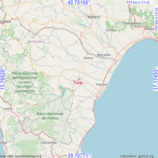
Tursi GPS coordinates[2]
40° 14' 47.436" North, 16° 28' 17.04" East
| Map corner | latitude | longitude |
|---|---|---|
| Upper-left | 40.78106°, | 15.76828° |
| Center: | 40.24651°, | 16.4714° |
| Lower-right: | 39.70771°, | 17.17453° |
| Map W x H: | 119.3×119.3 km | = 74.1×74.1mi |
| max Lat: | 47.04031° ⇑86.1% North |
| Tursi: | 40.24651° |
| min Lat: | ⇓13.9% South 35.50142° |
| min Long | Tursi | max Long |
| 6.69888° | 16.4714° | 18.48682° |
| W 96.2%⇐ | ⇒3.8% E |
Elevation
Elevation of Tursi is 188 m = 617 ft, and this is 118.7 m = 389 ft below average elevation for this country.
| Max E: |
2085 m = 6841 ft | 57% |
| Avg. | 306.7 m = 1006 ft | |
| Tursi | 188 m = 617 ft | |
Min E: |
-4 m = -13 ft | 43% |
See also: Italy elevation on elevation.city.
Geographical zone
Tursi is located in North temperate zone (between Tropic of Cancer and the Arctic Circle). Distance of this Northern Tropic circle is 1869.1 km =1161.4 mi to South.| Distance of | km | miles | from Tursi |
|---|---|---|---|
| North Pole | 5532.1 | 3437.5 | to North |
| Arctic Circle | 2926.2 | 1818.3 | to North |
| Tropic Cancer | 1869.1 | 1161.4 | to South |
| Equator | 4475 | 2780.6 | to South |


Nearby cities:
15 places around Tursi: (largest is in red/bold)
• Canna
17.1 km =10.6 mi,  170°
170°
• Colobraro
7.6 km =4.7 mi,  211°
211°
• Craco Peschiera
12.7 km =7.9 mi,  9°
9°
• Craco-Sant'Angelo
15.1 km =9.4 mi,  348°
348°
• Montalbano Jonico
9.4 km =5.8 mi,  62°
62°
• Nocara
16.4 km =10.2 mi,  176°
176°
• Nova Siri
12.4 km =7.7 mi,  152°
152°
• Pisticci
17.6 km =10.9 mi,  24°
24°
• Policoro
17.9 km =11.1 mi,  102°
102°
• Rocca Imperiale
17.7 km =11 mi, 149°
• Rotondella
9.5 km =5.9 mi, 151°
• San Brancato
18.3 km =11.4 mi,  274°
274°
• San Giorgio Lucano
16.6 km =10.3 mi,  204°
204°
• Sant'Arcangelo
17.1 km =10.6 mi, 270°
• Valsinni
8.7 km =5.4 mi, 195°
Sources, notices
• [Note1] Compared only with cities in Italy existing in our database
• [Src1] Map data: © OpenStreetMap contributors (CC-BY-SA)
• [Src2] Other city data from geonames.org with taken over terms of usage.
• [Src3] Geographical zone / Annual Mean Temperature by Robert A. Rohde @ Wikipedia
