Roseto Valfortore geodata
Roseto Valfortore (Apulia) is a seat of a third-order administrative division; located in Italy in Europe/Rome (GMT+2) time zone. With population of 1,145 people, there are 6129 cities with bigger population in this country. Compared to other cities in Italy, 75.6% of cities are located further ↑North; 88% of cities are located further ←West and 90.1% of cities have lower elevation than Roseto Valfortore. Note1


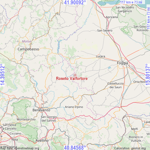
Roseto Valfortore GPS coordinates[2]
41° 22' 31.584" North, 15° 5' 53.664" East
| Map corner | latitude | longitude |
|---|---|---|
| Upper-left | 41.90092°, | 14.39512° |
| Center: | 41.37544°, | 15.09824° |
| Lower-right: | 40.84568°, | 15.80137° |
| Map W x H: | 117.3×117.3 km | = 72.9×72.9mi |
| max Lat: | 47.04031° ⇑75.6% North |
| Roseto Valfortore: | 41.37544° |
| min Lat: | ⇓24.4% South 35.50142° |
| min Long | Roseto Valforto | max Long |
| 6.69888° | 15.09824° | 18.48682° |
| W 88%⇐ | ⇒12% E |
Elevation
Elevation of Roseto Valfortore is 724 m = 2375 ft, and this is 417.3 m = 1369 ft above average elevation for this country.
| Max E: |
2085 m = 6841 ft | 9.9% |
| Roseto Valfortore | 724 m 2375 ft | |
| Avg. | 306.7 m = 1006 ft | |
Min E: |
-4 m = -13 ft | 90.1% |
See also: Italy elevation on elevation.city.
Geographical zone
Roseto Valfortore is located in North temperate zone (between Tropic of Cancer and the Arctic Circle). Distance of this Northern Tropic circle is 1994.6 km =1239.4 mi to South.| Distance of | km | miles | from Roseto Valfortore |
|---|---|---|---|
| North Pole | 5406.5 | 3359.4 | to North |
| Arctic Circle | 2800.7 | 1740.3 | to North |
| Tropic Cancer | 1994.6 | 1239.4 | to South |
| Equator | 4600.5 | 2858.6 | to South |


Nearby cities:
15 places around Roseto Valfortore: (largest is in red/bold)
• Alberona
6.6 km =4.1 mi,  18°
18°
• Baselice
10.6 km =6.6 mi,  280°
280°
• Biccari
8.5 km =5.3 mi,  73°
73°
• Castelfranco in Miscano
8.4 km =5.2 mi,  186°
186°
• Castelluccio Valmaggiore
9.2 km =5.7 mi,  113°
113°
• Celle di San Vito
8.8 km =5.5 mi,  128°
128°
• Faeto
7.7 km =4.8 mi,  137°
137°
• Foiano di Val Fortore
10.5 km =6.5 mi,  256°
256°
• Ginestra degli Schiavoni
11.6 km =7.2 mi,  203°
203°
• Greci
15 km =9.3 mi,  156°
156°
• Montefalcone di Val Fortore
9.4 km =5.8 mi,  232°
232°
• Motta Montecorvino
14.7 km =9.1 mi,  5°
5°
• San Bartolomeo in Galdo
8.1 km =5 mi,  303°
303°
• Volturara Appula
13.9 km =8.6 mi,  344°
344°
• Volturino
11.5 km =7.1 mi, 10°
Sources, notices
• [Note1] Compared only with cities in Italy existing in our database
• [Src1] Map data: © OpenStreetMap contributors (CC-BY-SA)
• [Src2] Other city data from geonames.org with taken over terms of usage.
• [Src3] Geographical zone / Annual Mean Temperature by Robert A. Rohde @ Wikipedia
