Volturino geodata
Volturino (Apulia) is a seat of a third-order administrative division; located in Italy in Europe/Rome (GMT+2) time zone. With population of 1,645 people, there are 4794 cities with bigger population in this country. Compared to other cities in Italy, 75% of cities are located further ↑North; 88.3% of cities are located further ←West and 90.4% of cities have lower elevation than Volturino. Note1


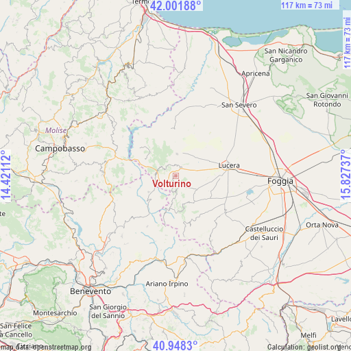
Volturino GPS coordinates[2]
41° 28' 38.028" North, 15° 7' 27.264" East
| Map corner | latitude | longitude |
|---|---|---|
| Upper-left | 42.00188°, | 14.42112° |
| Center: | 41.47723°, | 15.12424° |
| Lower-right: | 40.9483°, | 15.82737° |
| Map W x H: | 117.1×117.1 km | = 72.8×72.8mi |
| max Lat: | 47.04031° ⇑75% North |
| Volturino: | 41.47723° |
| min Lat: | ⇓25% South 35.50142° |
| min Long | Volturino | max Long |
| 6.69888° | 15.12424° | 18.48682° |
| W 88.3%⇐ | ⇒11.7% E |
Elevation
Elevation of Volturino is 729 m = 2392 ft, and this is 422.3 m = 1385 ft above average elevation for this country.
| Max E: |
2085 m = 6841 ft | 9.6% |
| Volturino | 729 m 2392 ft | |
| Avg. | 306.7 m = 1006 ft | |
Min E: |
-4 m = -13 ft | 90.4% |
See also: Italy elevation on elevation.city.
Geographical zone
Volturino is located in North temperate zone (between Tropic of Cancer and the Arctic Circle). Distance of this Northern Tropic circle is 2005.9 km =1246.4 mi to South.| Distance of | km | miles | from Volturino |
|---|---|---|---|
| North Pole | 5395.2 | 3352.4 | to North |
| Arctic Circle | 2789.3 | 1733.2 | to North |
| Tropic Cancer | 2005.9 | 1246.4 | to South |
| Equator | 4611.8 | 2865.6 | to South |


Nearby cities:
15 places around Volturino: (largest is in red/bold)
• Alberona
5 km =3.1 mi,  181°
181°
• Baselice
15.7 km =9.8 mi,  233°
233°
• Biccari
10.7 km =6.6 mi,  145°
145°
• Casalnuovo Monterotaro
15.9 km =9.9 mi,  353°
353°
• Casalvecchio di Puglia
13.1 km =8.1 mi, 354°
• Castelnuovo della Daunia
11.6 km =7.2 mi,  357°
357°
• Castelvetere in Val Fortore
15.7 km =9.8 mi,  255°
255°
• Celenza Valfortore
15.2 km =9.4 mi,  307°
307°
• Motta Montecorvino
3.5 km =2.2 mi, 345°
• Pietramontecorvino
7.2 km =4.5 mi,  3°
3°
• Roseto Valfortore
11.5 km =7.1 mi,  190°
190°
• San Bartolomeo in Galdo
11.2 km =7 mi, 232°
• San Marco la Catola
11.2 km =7 mi,  298°
298°
• Tufara
14.8 km =9.2 mi,  272°
272°
• Volturara Appula
6.4 km =4 mi,  289°
289°
Sources, notices
• [Note1] Compared only with cities in Italy existing in our database
• [Src1] Map data: © OpenStreetMap contributors (CC-BY-SA)
• [Src2] Other city data from geonames.org with taken over terms of usage.
• [Src3] Geographical zone / Annual Mean Temperature by Robert A. Rohde @ Wikipedia
