Biccari geodata
Biccari (Apulia) is a seat of a third-order administrative division; located in Italy in Europe/Rome (GMT+2) time zone. With population of 2,443 people, there are 3596 cities with bigger population in this country. Compared to other cities in Italy, 75.5% of cities are located further ↑North; 88.8% of cities are located further ←West and 74.5% of cities have lower elevation than Biccari. Note1


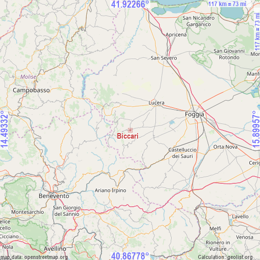
Biccari GPS coordinates[2]
41° 23' 50.496" North, 15° 11' 47.184" East
| Map corner | latitude | longitude |
|---|---|---|
| Upper-left | 41.92266°, | 14.49332° |
| Center: | 41.39736°, | 15.19644° |
| Lower-right: | 40.86778°, | 15.89957° |
| Map W x H: | 117.3×117.3 km | = 72.9×72.9mi |
| max Lat: | 47.04031° ⇑75.5% North |
| Biccari: | 41.39736° |
| min Lat: | ⇓24.5% South 35.50142° |
| min Long | Biccari | max Long |
| 6.69888° | 15.19644° | 18.48682° |
| W 88.8%⇐ | ⇒11.2% E |
Elevation
Elevation of Biccari is 445 m = 1460 ft, and this is 138.3 m = 454 ft above average elevation for this country.
| Max E: |
2085 m = 6841 ft | 25.5% |
| Biccari | 445 m 1460 ft | |
| Avg. | 306.7 m = 1006 ft | |
Min E: |
-4 m = -13 ft | 74.5% |
See also: Italy elevation on elevation.city.
Geographical zone
Biccari is located in North temperate zone (between Tropic of Cancer and the Arctic Circle). Distance of this Northern Tropic circle is 1997 km =1240.9 mi to South.| Distance of | km | miles | from Biccari |
|---|---|---|---|
| North Pole | 5404.1 | 3358 | to North |
| Arctic Circle | 2798.2 | 1738.7 | to North |
| Tropic Cancer | 1997 | 1240.9 | to South |
| Equator | 4603 | 2860.2 | to South |


Nearby cities:
15 places around Biccari: (largest is in red/bold)
• Alberona
7.2 km =4.5 mi,  302°
302°
• Castelfranco in Miscano
14.2 km =8.8 mi,  220°
220°
• Castelluccio Valmaggiore
6.1 km =3.8 mi,  177°
177°
• Celle di San Vito
8 km =5 mi,  189°
189°
• Faeto
8.6 km =5.3 mi,  200°
200°
• Greci
16.3 km =10.1 mi, 188°
• Lucera
16.9 km =10.5 mi,  44°
44°
• Montaguto
17.1 km =10.6 mi,  165°
165°
• Motta Montecorvino
14 km =8.7 mi,  330°
330°
• Orsara di Puglia
14.2 km =8.8 mi,  155°
155°
• Roseto Valfortore
8.5 km =5.3 mi,  253°
253°
• San Bartolomeo in Galdo
15.1 km =9.4 mi,  277°
277°
• Troia
10.7 km =6.6 mi,  110°
110°
• Volturara Appula
16.3 km =10.1 mi,  312°
312°
• Volturino
10.7 km =6.6 mi, 325°
Sources, notices
• [Note1] Compared only with cities in Italy existing in our database
• [Src1] Map data: © OpenStreetMap contributors (CC-BY-SA)
• [Src2] Other city data from geonames.org with taken over terms of usage.
• [Src3] Geographical zone / Annual Mean Temperature by Robert A. Rohde @ Wikipedia
