Rosate geodata
Rosate (Lombardy) is a seat of a third-order administrative division; located in Italy in Europe/Rome (GMT+2) time zone. With population of 5,158 people, there are 1894 cities with bigger population in this country. Compared to other cities in Italy, 68.8% of cities are located further ↓South; 81% of cities are located further →East and 68.3% of cities have higher elevation than Rosate. Note1
Administrative division(s):
- Level 1: Lombardy
- Level 2: Città metropolitana di Milano
- Level 3: Rosate


Rosate GPS coordinates[2]
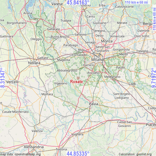
45° 20' 58.74" North, 9° 0' 59.724" East
| Map corner | latitude | longitude |
|---|---|---|
| Upper-left | 45.84163°, | 8.31347° |
| Center: | 45.34965°, | 9.01659° |
| Lower-right: | 44.85335°, | 9.71972° |
| Map W x H: | 109.9×109.9 km | = 68.3×68.3mi |
| max Lat: | 47.04031° ⇑31.2% North |
| Rosate: | 45.34965° |
| min Lat: | ⇓68.8% South 35.50142° |
| min Long | Rosate | max Long |
| 6.69888° | 9.01659° | 18.48682° |
| W 19%⇐ | ⇒81% E |
Elevation
Elevation of Rosate is 107 m = 351 ft, and this is 199.7 m = 655 ft below average elevation for this country.
| Max E: |
2085 m = 6841 ft | 68.3% |
| Avg. | 306.7 m = 1006 ft | |
| Rosate | 107 m = 351 ft | |
Min E: |
-4 m = -13 ft | 31.7% |
See also: Italy elevation on elevation.city.
Geographical zone
Rosate is located in North temperate zone (between Tropic of Cancer and the Arctic Circle). Distance of this North polar circle is 2358.8 km =1465.7 mi to North.| Distance of | km | miles | from Rosate |
|---|---|---|---|
| North Pole | 4964.7 | 3084.9 | to North |
| Arctic Circle | 2358.8 | 1465.7 | to North |
| Tropic Cancer | 2436.5 | 1514 | to South |
| Equator | 5042.4 | 3133.2 | to South |


Nearby cities:
15 places around Rosate: (largest is in red/bold)
• Besate
5.5 km =3.4 mi,  221°
221°
• Bettola
2 km =1.2 mi,  170°
170°
• Bubbiano
2.5 km =1.6 mi,  183°
183°
• Calvignasco
2.8 km =1.7 mi,  161°
161°
• Casorate Primo
4.3 km =2.7 mi, 179°
• Gudo Visconti
3 km =1.9 mi,  334°
334°
• Mairano
4.2 km =2.6 mi,  77°
77°
• Moncucco
4.7 km =2.9 mi, 157°
• Morimondo
4.7 km =2.9 mi,  275°
275°
• Noviglio
3 km =1.9 mi,  69°
69°
• Pasturago
5.4 km =3.4 mi,  117°
117°
• Santa Corinna
5.7 km =3.5 mi,  100°
100°
• Vernate
5.1 km =3.2 mi,  137°
137°
• Vigano
3.7 km =2.3 mi,  15°
15°
• Zelo Surrigone
4.9 km =3 mi, 329°
Sources, notices
• [Note1] Compared only with cities in Italy existing in our database
• [Src1] Map data: © OpenStreetMap contributors (CC-BY-SA)
• [Src2] Other city data from geonames.org with taken over terms of usage.
• [Src3] Geographical zone / Annual Mean Temperature by Robert A. Rohde @ Wikipedia
