Vernate geodata
Vernate (Lombardy) is a seat of a third-order administrative division; located in Italy in Europe/Rome (GMT+2) time zone. With population of 406 people, there are 10253 cities with bigger population in this country. Compared to other cities in Italy, 67.9% of cities are located further ↓South; 80.3% of cities are located further →East and 69.3% of cities have higher elevation than Vernate. Note1
Administrative division(s):
- Level 1: Lombardy
- Level 2: Città metropolitana di Milano
- Level 3: Vernate


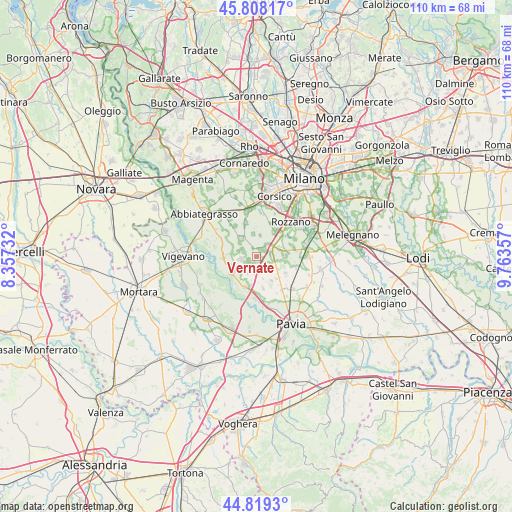
Vernate GPS coordinates[2]
45° 18' 57.204" North, 9° 3' 37.62" East
| Map corner | latitude | longitude |
|---|---|---|
| Upper-left | 45.80817°, | 8.35732° |
| Center: | 45.31589°, | 9.06045° |
| Lower-right: | 44.8193°, | 9.76357° |
| Map W x H: | 110×110 km | = 68.4×68.4mi |
| max Lat: | 47.04031° ⇑32.1% North |
| Vernate: | 45.31589° |
| min Lat: | ⇓67.9% South 35.50142° |
| min Long | Vernate | max Long |
| 6.69888° | 9.06045° | 18.48682° |
| W 19.7%⇐ | ⇒80.3% E |
Elevation
Elevation of Vernate is 101 m = 331 ft, and this is 205.7 m = 675 ft below average elevation for this country.
| Max E: |
2085 m = 6841 ft | 69.3% |
| Avg. | 306.7 m = 1006 ft | |
| Vernate | 101 m = 331 ft | |
Min E: |
-4 m = -13 ft | 30.7% |
See also: Italy elevation on elevation.city.
Geographical zone
Vernate is located in North temperate zone (between Tropic of Cancer and the Arctic Circle). Distance of this North polar circle is 2362.5 km =1468 mi to North.| Distance of | km | miles | from Vernate |
|---|---|---|---|
| North Pole | 4968.4 | 3087.2 | to North |
| Arctic Circle | 2362.5 | 1468 | to North |
| Tropic Cancer | 2432.7 | 1511.6 | to South |
| Equator | 5038.7 | 3130.9 | to South |


Nearby cities:
15 places around Vernate: (largest is in red/bold)
• Battuda
4.8 km =3 mi,  163°
163°
• Bettola
3.6 km =2.2 mi,  299°
299°
• Binasco
3.1 km =1.9 mi,  57°
57°
• Bubbiano
3.8 km =2.4 mi,  289°
289°
• Calvignasco
2.8 km =1.7 mi, 293°
• Casarile
3.4 km =2.1 mi,  88°
88°
• Casorate Primo
3.4 km =2.1 mi,  261°
261°
• Mairano
4.7 km =2.9 mi,  8°
8°
• Moncucco
1.8 km =1.1 mi,  249°
249°
• Noviglio
4.8 km =3 mi,  352°
352°
• Pasturago
1.8 km =1.1 mi,  46°
46°
• Rognano
3.8 km =2.4 mi,  142°
142°
• Rosate
5.1 km =3.2 mi,  317°
317°
• Santa Corinna
3.5 km =2.2 mi,  39°
39°
• Trovo
4.2 km =2.6 mi,  208°
208°
Sources, notices
• [Note1] Compared only with cities in Italy existing in our database
• [Src1] Map data: © OpenStreetMap contributors (CC-BY-SA)
• [Src2] Other city data from geonames.org with taken over terms of usage.
• [Src3] Geographical zone / Annual Mean Temperature by Robert A. Rohde @ Wikipedia
