Bettola geodata
Bettola (Lombardy) is a seat of a third-order administrative division; located in Italy in Europe/Rome (GMT+2) time zone. With population of 1,052 people, there are 6463 cities with bigger population in this country. Compared to other cities in Italy, 68.4% of cities are located further ↓South; 81% of cities are located further →East and 69% of cities have higher elevation than Bettola. Note1
Administrative division(s):
- Level 1: Lombardy
- Level 2: Città metropolitana di Milano
- Level 3: Calvignasco


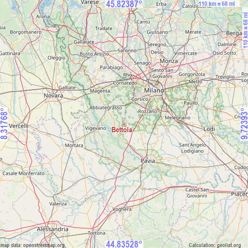
Bettola GPS coordinates[2]
45° 19' 54.228" North, 9° 1' 14.88" East
| Map corner | latitude | longitude |
|---|---|---|
| Upper-left | 45.82387°, | 8.31768° |
| Center: | 45.33173°, | 9.0208° |
| Lower-right: | 44.83528°, | 9.72393° |
| Map W x H: | 109.9×109.9 km | = 68.3×68.3mi |
| max Lat: | 47.04031° ⇑31.6% North |
| Bettola: | 45.33173° |
| min Lat: | ⇓68.4% South 35.50142° |
| min Long | Bettola | max Long |
| 6.69888° | 9.0208° | 18.48682° |
| W 19%⇐ | ⇒81% E |
Elevation
Elevation of Bettola is 103 m = 338 ft, and this is 203.7 m = 668 ft below average elevation for this country.
| Max E: |
2085 m = 6841 ft | 69% |
| Avg. | 306.7 m = 1006 ft | |
| Bettola | 103 m = 338 ft | |
Min E: |
-4 m = -13 ft | 31% |
See also: Italy elevation on elevation.city.
Geographical zone
Bettola is located in North temperate zone (between Tropic of Cancer and the Arctic Circle). Distance of this North polar circle is 2360.8 km =1466.9 mi to North.| Distance of | km | miles | from Bettola |
|---|---|---|---|
| North Pole | 4966.6 | 3086.1 | to North |
| Arctic Circle | 2360.8 | 1466.9 | to North |
| Tropic Cancer | 2434.5 | 1512.7 | to South |
| Equator | 5040.4 | 3132 | to South |


Nearby cities:
15 places around Bettola: (largest is in red/bold)
• Besate
4.5 km =2.8 mi,  242°
242°
• Bubbiano
0.7 km =0.4 mi,  224°
224°
• Calvignasco
0.8 km =0.5 mi,  139°
139°
• Casorate Primo
2.3 km =1.4 mi,  187°
187°
• Gudo Visconti
5 km =3.1 mi,  341°
341°
• Mairano
4.8 km =3 mi,  52°
52°
• Moncucco
2.8 km =1.7 mi,  148°
148°
• Motta Visconti
5.4 km =3.4 mi,  204°
204°
• Noviglio
3.9 km =2.4 mi,  38°
38°
• Pasturago
4.5 km =2.8 mi,  96°
96°
• Rosate
2 km =1.2 mi,  350°
350°
• Santa Corinna
5.4 km =3.4 mi,  79°
79°
• Trovo
5.5 km =3.4 mi,  168°
168°
• Vernate
3.6 km =2.2 mi,  119°
119°
• Vigano
5.6 km =3.5 mi,  6°
6°
Sources, notices
• [Note1] Compared only with cities in Italy existing in our database
• [Src1] Map data: © OpenStreetMap contributors (CC-BY-SA)
• [Src2] Other city data from geonames.org with taken over terms of usage.
• [Src3] Geographical zone / Annual Mean Temperature by Robert A. Rohde @ Wikipedia
