Romanengo geodata
Romanengo (Lombardy) is a seat of a third-order administrative division; located in Italy in Europe/Rome (GMT+2) time zone. With population of 2,921 people, there are 3106 cities with bigger population in this country. Compared to other cities in Italy, 69.6% of cities are located further ↓South; 69.9% of cities are located further →East and 73.4% of cities have higher elevation than Romanengo. Note1


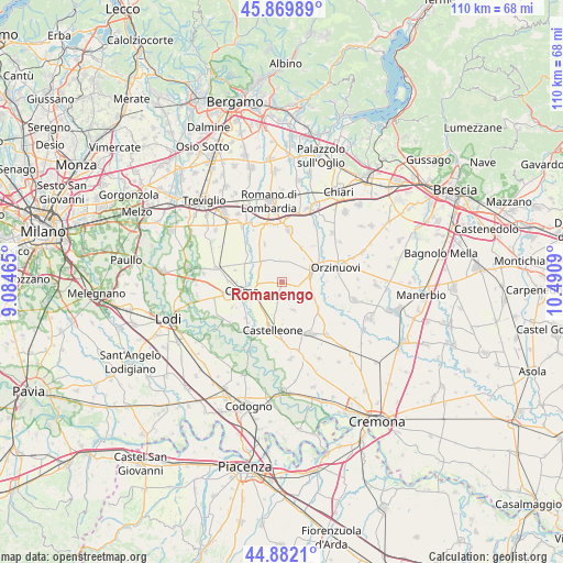
Romanengo GPS coordinates[2]
45° 22' 41.34" North, 9° 47' 15.972" East
| Map corner | latitude | longitude |
|---|---|---|
| Upper-left | 45.86989°, | 9.08465° |
| Center: | 45.37815°, | 9.78777° |
| Lower-right: | 44.8821°, | 10.4909° |
| Map W x H: | 109.8×109.8 km | = 68.2×68.2mi |
| max Lat: | 47.04031° ⇑30.4% North |
| Romanengo: | 45.37815° |
| min Lat: | ⇓69.6% South 35.50142° |
| min Long | Romanengo | max Long |
| 6.69888° | 9.78777° | 18.48682° |
| W 30.1%⇐ | ⇒69.9% E |
Elevation
Elevation of Romanengo is 81 m = 266 ft, and this is 225.7 m = 740 ft below average elevation for this country.
| Max E: |
2085 m = 6841 ft | 73.4% |
| Avg. | 306.7 m = 1006 ft | |
| Romanengo | 81 m = 266 ft | |
Min E: |
-4 m = -13 ft | 26.6% |
See also: Italy elevation on elevation.city.
Geographical zone
Romanengo is located in North temperate zone (between Tropic of Cancer and the Arctic Circle). Distance of this North polar circle is 2355.6 km =1463.7 mi to North.| Distance of | km | miles | from Romanengo |
|---|---|---|---|
| North Pole | 4961.5 | 3082.9 | to North |
| Arctic Circle | 2355.6 | 1463.7 | to North |
| Tropic Cancer | 2439.7 | 1516 | to South |
| Equator | 5045.6 | 3135.2 | to South |


Nearby cities:
15 places around Romanengo: (largest is in red/bold)
• Bottaiano
5.5 km =3.4 mi,  319°
319°
• Camisano
8.1 km =5 mi,  335°
335°
• Casaletto di Sopra
4.6 km =2.9 mi,  354°
354°
• Cumignano sul Naviglio
4.6 km =2.9 mi,  124°
124°
• Fiesco
4.6 km =2.9 mi,  189°
189°
• Gallignano
7.7 km =4.8 mi,  30°
30°
• Izano
3.8 km =2.4 mi,  228°
228°
• Madignano
6.3 km =3.9 mi, 234°
• Offanengo
3.5 km =2.2 mi,  271°
271°
• Pianengo
7.7 km =4.8 mi,  290°
290°
• Ricengo
5.8 km =3.6 mi,  301°
301°
• Salvirola
2.5 km =1.6 mi,  195°
195°
• Soncino
6.8 km =4.2 mi,  68°
68°
• Ticengo
3.3 km =2.1 mi,  107°
107°
• Trigolo
5.7 km =3.5 mi,  158°
158°
Sources, notices
• [Note1] Compared only with cities in Italy existing in our database
• [Src1] Map data: © OpenStreetMap contributors (CC-BY-SA)
• [Src2] Other city data from geonames.org with taken over terms of usage.
• [Src3] Geographical zone / Annual Mean Temperature by Robert A. Rohde @ Wikipedia
