Salvirola geodata
Salvirola (Lombardy) is a seat of a third-order administrative division; located in Italy in Europe/Rome (GMT+2) time zone. With population of 1,118 people, there are 6220 cities with bigger population in this country. Compared to other cities in Italy, 69% of cities are located further ↓South; 69.9% of cities are located further →East and 75.2% of cities have higher elevation than Salvirola. Note1


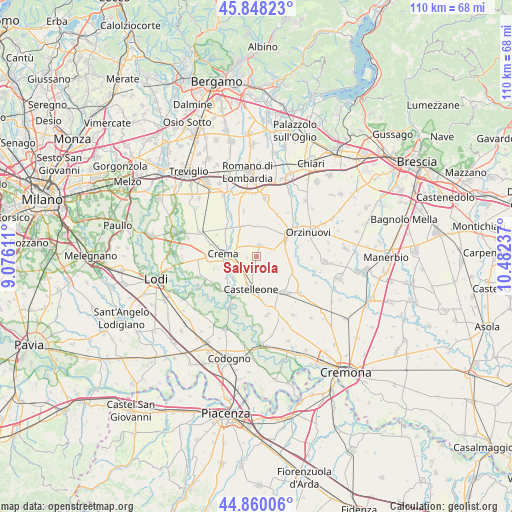
Salvirola GPS coordinates[2]
45° 21' 22.68" North, 9° 46' 45.264" East
| Map corner | latitude | longitude |
|---|---|---|
| Upper-left | 45.84823°, | 9.07611° |
| Center: | 45.3563°, | 9.77924° |
| Lower-right: | 44.86006°, | 10.48237° |
| Map W x H: | 109.9×109.9 km | = 68.3×68.3mi |
| max Lat: | 47.04031° ⇑31% North |
| Salvirola: | 45.3563° |
| min Lat: | ⇓69% South 35.50142° |
| min Long | Salvirola | max Long |
| 6.69888° | 9.77924° | 18.48682° |
| W 30.1%⇐ | ⇒69.9% E |
Elevation
Elevation of Salvirola is 73 m = 240 ft, and this is 233.7 m = 767 ft below average elevation for this country.
| Max E: |
2085 m = 6841 ft | 75.2% |
| Avg. | 306.7 m = 1006 ft | |
| Salvirola | 73 m = 240 ft | |
Min E: |
-4 m = -13 ft | 24.8% |
See also: Italy elevation on elevation.city.
Geographical zone
Salvirola is located in North temperate zone (between Tropic of Cancer and the Arctic Circle). Distance of this North polar circle is 2358 km =1465.2 mi to North.| Distance of | km | miles | from Salvirola |
|---|---|---|---|
| North Pole | 4963.9 | 3084.4 | to North |
| Arctic Circle | 2358 | 1465.2 | to North |
| Tropic Cancer | 2437.2 | 1514.4 | to South |
| Equator | 5043.1 | 3133.6 | to South |


Nearby cities:
15 places around Salvirola: (largest is in red/bold)
• Bottaiano
7.2 km =4.5 mi,  336°
336°
• Casaletto di Sopra
7 km =4.3 mi,  2°
2°
• Castelleone
6.9 km =4.3 mi,  192°
192°
• Crema
7.6 km =4.7 mi,  275°
275°
• Cumignano sul Naviglio
4.5 km =2.8 mi,  92°
92°
• Fiesco
2.1 km =1.3 mi,  182°
182°
• Izano
2.2 km =1.4 mi,  267°
267°
• Madignano
4.6 km =2.9 mi,  254°
254°
• Offanengo
3.8 km =2.4 mi,  311°
311°
• Ricengo
7 km =4.3 mi,  321°
321°
• Ripalta Arpina
7.2 km =4.5 mi,  213°
213°
• Ripalta Nuova
7.3 km =4.5 mi, 248°
• Romanengo
2.5 km =1.6 mi,  15°
15°
• Ticengo
4 km =2.5 mi,  69°
69°
• Trigolo
4 km =2.5 mi,  137°
137°
Sources, notices
• [Note1] Compared only with cities in Italy existing in our database
• [Src1] Map data: © OpenStreetMap contributors (CC-BY-SA)
• [Src2] Other city data from geonames.org with taken over terms of usage.
• [Src3] Geographical zone / Annual Mean Temperature by Robert A. Rohde @ Wikipedia
