Rocchetta geodata
Rocchetta (Campania) is a seat of a third-order administrative division; located in Italy in Europe/Rome (GMT+2) time zone. With population of 255 people, there are 10870 cities with bigger population in this country. Compared to other cities in Italy, 76.6% of cities are located further ↑North; 79.4% of cities are located further ←West and 74.1% of cities have lower elevation than Rocchetta. Note1
Administrative division(s):
- Level 1: Campania
- Level 2: Provincia di Caserta
- Level 3: Rocchetta e Croce


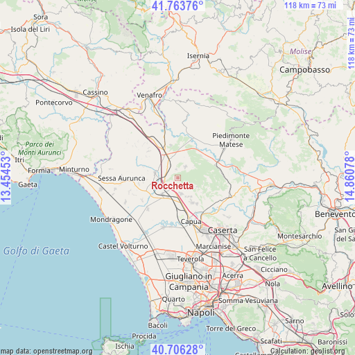
Rocchetta GPS coordinates[2]
41° 14' 13.776" North, 14° 9' 27.54" East
| Map corner | latitude | longitude |
|---|---|---|
| Upper-left | 41.76376°, | 13.45453° |
| Center: | 41.23716°, | 14.15765° |
| Lower-right: | 40.70628°, | 14.86078° |
| Map W x H: | 117.6×117.6 km | = 73.1×73.1mi |
| max Lat: | 47.04031° ⇑76.6% North |
| Rocchetta: | 41.23716° |
| min Lat: | ⇓23.4% South 35.50142° |
| min Long | Rocchetta | max Long |
| 6.69888° | 14.15765° | 18.48682° |
| W 79.4%⇐ | ⇒20.6% E |
Elevation
Elevation of Rocchetta is 440 m = 1444 ft, and this is 133.3 m = 437 ft above average elevation for this country.
| Max E: |
2085 m = 6841 ft | 25.9% |
| Rocchetta | 440 m 1444 ft | |
| Avg. | 306.7 m = 1006 ft | |
Min E: |
-4 m = -13 ft | 74.1% |
See also: Italy elevation on elevation.city.
Geographical zone
Rocchetta is located in North temperate zone (between Tropic of Cancer and the Arctic Circle). Distance of this Northern Tropic circle is 1979.2 km =1229.8 mi to South.| Distance of | km | miles | from Rocchetta |
|---|---|---|---|
| North Pole | 5421.9 | 3369 | to North |
| Arctic Circle | 2816 | 1749.8 | to North |
| Tropic Cancer | 1979.2 | 1229.8 | to South |
| Equator | 4585.1 | 2849 | to South |


Nearby cities:
15 places around Rocchetta: (largest is in red/bold)
• Calvi Risorta
3.2 km =2 mi,  223°
223°
• Camigliano
7.6 km =4.7 mi,  144°
144°
• Formicola
7.1 km =4.4 mi,  114°
114°
• Giano Vetusto
4.9 km =3 mi, 142°
• Pastorano
7.1 km =4.4 mi,  151°
151°
• Pietramelara
4.5 km =2.8 mi,  33°
33°
• Pignataro Maggiore
5.3 km =3.3 mi,  169°
169°
• Pontelatone
8.9 km =5.5 mi,  122°
122°
• Pozzillo
4.9 km =3 mi, 140°
• Riardo
2.8 km =1.7 mi,  347°
347°
• Roccaromana
6.7 km =4.2 mi,  52°
52°
• Scalo Ferroviario
6.9 km =4.3 mi,  265°
265°
• Sparanise
7.5 km =4.7 mi, 223°
• Teano
7.8 km =4.8 mi,  281°
281°
• Zuni
3.2 km =2 mi,  225°
225°
Sources, notices
• [Note1] Compared only with cities in Italy existing in our database
• [Src1] Map data: © OpenStreetMap contributors (CC-BY-SA)
• [Src2] Other city data from geonames.org with taken over terms of usage.
• [Src3] Geographical zone / Annual Mean Temperature by Robert A. Rohde @ Wikipedia
