Pastorano geodata
Pastorano (Campania) is a seat of a third-order administrative division; located in Italy in Europe/Rome (GMT+2) time zone. With population of 2,586 people, there are 3426 cities with bigger population in this country. Compared to other cities in Italy, 77.1% of cities are located further ↑North; 79.8% of cities are located further ←West and 75.2% of cities have higher elevation than Pastorano. Note1


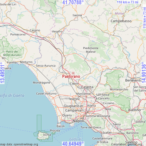
Pastorano GPS coordinates[2]
41° 10' 50.952" North, 14° 11' 53.628" East
| Map corner | latitude | longitude |
|---|---|---|
| Upper-left | 41.70788°, | 13.49511° |
| Center: | 41.18082°, | 14.19823° |
| Lower-right: | 40.64949°, | 14.90136° |
| Map W x H: | 117.7×117.7 km | = 73.1×73.1mi |
| max Lat: | 47.04031° ⇑77.1% North |
| Pastorano: | 41.18082° |
| min Lat: | ⇓22.9% South 35.50142° |
| min Long | Pastorano | max Long |
| 6.69888° | 14.19823° | 18.48682° |
| W 79.8%⇐ | ⇒20.2% E |
Elevation
Elevation of Pastorano is 73 m = 240 ft, and this is 233.7 m = 767 ft below average elevation for this country.
| Max E: |
2085 m = 6841 ft | 75.2% |
| Avg. | 306.7 m = 1006 ft | |
| Pastorano | 73 m = 240 ft | |
Min E: |
-4 m = -13 ft | 24.8% |
See also: Italy elevation on elevation.city.
Geographical zone
Pastorano is located in North temperate zone (between Tropic of Cancer and the Arctic Circle). Distance of this Northern Tropic circle is 1973 km =1226 mi to South.| Distance of | km | miles | from Pastorano |
|---|---|---|---|
| North Pole | 5428.2 | 3372.9 | to North |
| Arctic Circle | 2822.3 | 1753.7 | to North |
| Tropic Cancer | 1973 | 1226 | to South |
| Equator | 4578.9 | 2845.2 | to South |


Nearby cities:
15 places around Pastorano: (largest is in red/bold)
• Bellona
3.7 km =2.3 mi,  127°
127°
• Calvi Risorta
6.9 km =4.3 mi,  304°
304°
• Camigliano
1 km =0.6 mi,  87°
87°
• Capua
8.5 km =5.3 mi,  171°
171°
• Castel di Sasso
6.8 km =4.2 mi,  79°
79°
• Formicola
4.5 km =2.8 mi,  42°
42°
• Giano Vetusto
2.5 km =1.6 mi,  350°
350°
• Pignataro Maggiore
2.6 km =1.6 mi,  293°
293°
• Pontelatone
4.4 km =2.7 mi,  69°
69°
• Pozzillo
2.5 km =1.6 mi, 354°
• Rocchetta
7.1 km =4.4 mi,  331°
331°
• Sant'Angelo in Formis
8.3 km =5.2 mi,  148°
148°
• Sparanise
8.6 km =5.3 mi,  275°
275°
• Vitulazio
2.4 km =1.5 mi, 147°
• Zuni
6.9 km =4.3 mi,  305°
305°
Sources, notices
• [Note1] Compared only with cities in Italy existing in our database
• [Src1] Map data: © OpenStreetMap contributors (CC-BY-SA)
• [Src2] Other city data from geonames.org with taken over terms of usage.
• [Src3] Geographical zone / Annual Mean Temperature by Robert A. Rohde @ Wikipedia
