Zuni geodata
Zuni (Campania) is a seat of a third-order administrative division; located in Italy in Europe/Rome (GMT+2) time zone. With population of 5,856 people, there are 1676 cities with bigger population in this country. Compared to other cities in Italy, 76.8% of cities are located further ↑North; 79.2% of cities are located further ←West and 66.5% of cities have higher elevation than Zuni. Note1


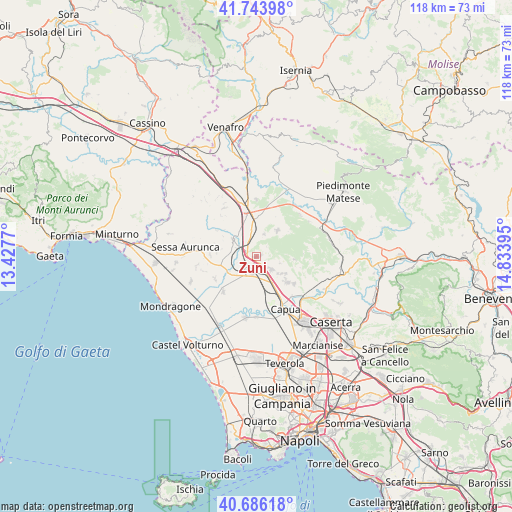
Zuni GPS coordinates[2]
41° 13' 1.992" North, 14° 7' 50.952" East
| Map corner | latitude | longitude |
|---|---|---|
| Upper-left | 41.74398°, | 13.4277° |
| Center: | 41.21722°, | 14.13082° |
| Lower-right: | 40.68618°, | 14.83395° |
| Map W x H: | 117.6×117.6 km | = 73.1×73.1mi |
| max Lat: | 47.04031° ⇑76.8% North |
| Zuni: | 41.21722° |
| min Lat: | ⇓23.2% South 35.50142° |
| min Long | Zuni | max Long |
| 6.69888° | 14.13082° | 18.48682° |
| W 79.2%⇐ | ⇒20.8% E |
Elevation
Elevation of Zuni is 118 m = 387 ft, and this is 188.7 m = 619 ft below average elevation for this country.
| Max E: |
2085 m = 6841 ft | 66.5% |
| Avg. | 306.7 m = 1006 ft | |
| Zuni | 118 m = 387 ft | |
Min E: |
-4 m = -13 ft | 33.5% |
See also: Italy elevation on elevation.city.
Geographical zone
Zuni is located in North temperate zone (between Tropic of Cancer and the Arctic Circle). Distance of this Northern Tropic circle is 1977 km =1228.5 mi to South.| Distance of | km | miles | from Zuni |
|---|---|---|---|
| North Pole | 5424.1 | 3370.4 | to North |
| Arctic Circle | 2818.2 | 1751.1 | to North |
| Tropic Cancer | 1977 | 1228.5 | to South |
| Equator | 4582.9 | 2847.7 | to South |


Nearby cities:
15 places around Zuni: (largest is in red/bold)
• Calvi Risorta
0.1 km =0.1 mi,  176°
176°
• Camigliano
7.7 km =4.8 mi,  121°
121°
• Casi
9.1 km =5.7 mi,  300°
300°
• Formicola
8.7 km =5.4 mi,  94°
94°
• Francolise
7.2 km =4.5 mi,  239°
239°
• Giano Vetusto
5.5 km =3.4 mi,  107°
107°
• Pastorano
6.9 km =4.3 mi,  125°
125°
• Pietramelara
7.6 km =4.7 mi,  38°
38°
• Pignataro Maggiore
4.4 km =2.7 mi, 132°
• Pozzillo
5.6 km =3.5 mi, 105°
• Riardo
5.2 km =3.2 mi,  18°
18°
• Rocchetta
3.2 km =2 mi,  45°
45°
• Scalo Ferroviario
5 km =3.1 mi,  290°
290°
• Sparanise
4.4 km =2.7 mi,  221°
221°
• Teano
6.6 km =4.1 mi,  305°
305°
Sources, notices
• [Note1] Compared only with cities in Italy existing in our database
• [Src1] Map data: © OpenStreetMap contributors (CC-BY-SA)
• [Src2] Other city data from geonames.org with taken over terms of usage.
• [Src3] Geographical zone / Annual Mean Temperature by Robert A. Rohde @ Wikipedia
