Roccavivara geodata
Roccavivara (Molise) is a seat of a third-order administrative division; located in Italy in Europe/Rome (GMT+2) time zone. With population of 739 people, there are 8029 cities with bigger population in this country. Compared to other cities in Italy, 71.7% of cities are located further ↑North; 83.6% of cities are located further ←West and 88.4% of cities have lower elevation than Roccavivara. Note1


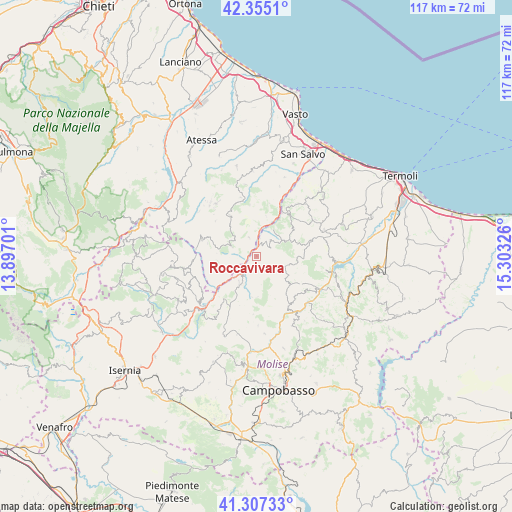
Roccavivara GPS coordinates[2]
41° 50' 0.096" North, 14° 36' 0.468" East
| Map corner | latitude | longitude |
|---|---|---|
| Upper-left | 42.3551°, | 13.89701° |
| Center: | 41.83336°, | 14.60013° |
| Lower-right: | 41.30733°, | 15.30326° |
| Map W x H: | 116.5×116.5 km | = 72.4×72.4mi |
| max Lat: | 47.04031° ⇑71.7% North |
| Roccavivara: | 41.83336° |
| min Lat: | ⇓28.3% South 35.50142° |
| min Long | Roccavivara | max Long |
| 6.69888° | 14.60013° | 18.48682° |
| W 83.6%⇐ | ⇒16.4% E |
Elevation
Elevation of Roccavivara is 680 m = 2231 ft, and this is 373.3 m = 1225 ft above average elevation for this country.
| Max E: |
2085 m = 6841 ft | 11.6% |
| Roccavivara | 680 m 2231 ft | |
| Avg. | 306.7 m = 1006 ft | |
Min E: |
-4 m = -13 ft | 88.4% |
See also: Italy elevation on elevation.city.
Geographical zone
Roccavivara is located in North temperate zone (between Tropic of Cancer and the Arctic Circle). Distance of this Northern Tropic circle is 2045.5 km =1271 mi to South.| Distance of | km | miles | from Roccavivara |
|---|---|---|---|
| North Pole | 5355.6 | 3327.8 | to North |
| Arctic Circle | 2749.7 | 1708.6 | to North |
| Tropic Cancer | 2045.5 | 1271 | to South |
| Equator | 4651.4 | 2890.2 | to South |


Nearby cities:
15 places around Roccavivara: (largest is in red/bold)
• Carunchio
11.2 km =7 mi,  327°
327°
• Castelguidone
6.5 km =4 mi,  259°
259°
• Castelmauro
9.2 km =5.7 mi,  93°
93°
• Celenza sul Trigno
4.6 km =2.9 mi,  337°
337°
• Civitacampomarano
9.4 km =5.8 mi,  128°
128°
• Montefalcone nel Sannio
4.9 km =3 mi,  40°
40°
• Montemitro
7.2 km =4.5 mi,  32°
32°
• Palmoli
11.9 km =7.4 mi,  352°
352°
• Salcito
12.2 km =7.6 mi,  217°
217°
• San Felice del Molise
10.5 km =6.5 mi,  52°
52°
• San Giovanni Lipioni
3.3 km =2.1 mi,  290°
290°
• Schiavi di Abruzzo
9.7 km =6 mi, 256°
• Torrebruna
6.2 km =3.9 mi,  307°
307°
• Trivento
8.3 km =5.2 mi,  212°
212°
• Tufillo
9.5 km =5.9 mi,  12°
12°
Sources, notices
• [Note1] Compared only with cities in Italy existing in our database
• [Src1] Map data: © OpenStreetMap contributors (CC-BY-SA)
• [Src2] Other city data from geonames.org with taken over terms of usage.
• [Src3] Geographical zone / Annual Mean Temperature by Robert A. Rohde @ Wikipedia
