Montemitro geodata
Montemitro (Molise) is a seat of a third-order administrative division; located in Italy in Europe/Rome (GMT+2) time zone. With population of 454 people, there are 10078 cities with bigger population in this country. Compared to other cities in Italy, 71.3% of cities are located further ↑North; 84% of cities are located further ←West and 77.3% of cities have lower elevation than Montemitro. Note1


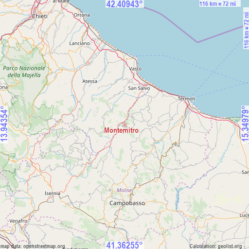
Montemitro GPS coordinates[2]
41° 53' 17.268" North, 14° 38' 47.976" East
| Map corner | latitude | longitude |
|---|---|---|
| Upper-left | 42.40943°, | 13.94354° |
| Center: | 41.88813°, | 14.64666° |
| Lower-right: | 41.36255°, | 15.34979° |
| Map W x H: | 116.4×116.4 km | = 72.3×72.3mi |
| max Lat: | 47.04031° ⇑71.3% North |
| Montemitro: | 41.88813° |
| min Lat: | ⇓28.7% South 35.50142° |
| min Long | Montemitro | max Long |
| 6.69888° | 14.64666° | 18.48682° |
| W 84%⇐ | ⇒16% E |
Elevation
Elevation of Montemitro is 483 m = 1585 ft, and this is 176.3 m = 578 ft above average elevation for this country.
| Max E: |
2085 m = 6841 ft | 22.7% |
| Montemitro | 483 m 1585 ft | |
| Avg. | 306.7 m = 1006 ft | |
Min E: |
-4 m = -13 ft | 77.3% |
See also: Italy elevation on elevation.city.
Geographical zone
Montemitro is located in North temperate zone (between Tropic of Cancer and the Arctic Circle). Distance of this Northern Tropic circle is 2051.6 km =1274.8 mi to South.| Distance of | km | miles | from Montemitro |
|---|---|---|---|
| North Pole | 5349.5 | 3324 | to North |
| Arctic Circle | 2743.7 | 1704.9 | to North |
| Tropic Cancer | 2051.6 | 1274.8 | to South |
| Equator | 4657.5 | 2894 | to South |


Nearby cities:
15 places around Montemitro: (largest is in red/bold)
• Acquaviva Collecroce
8.7 km =5.4 mi,  106°
106°
• Carunchio
10.4 km =6.5 mi,  288°
288°
• Castelmauro
8.5 km =5.3 mi,  141°
141°
• Celenza sul Trigno
5.9 km =3.7 mi,  252°
252°
• Dogliola
6.1 km =3.8 mi,  350°
350°
• Fresagrandinaria
10.2 km =6.3 mi,  7°
7°
• Mafalda
8.4 km =5.2 mi,  43°
43°
• Montefalcone nel Sannio
2.5 km =1.6 mi,  196°
196°
• Palmoli
7.9 km =4.9 mi,  316°
316°
• Roccavivara
7.2 km =4.5 mi,  212°
212°
• San Felice del Molise
4.5 km =2.8 mi,  87°
87°
• San Giovanni Lipioni
8.5 km =5.3 mi,  234°
234°
• Tavenna
9.8 km =6.1 mi,  76°
76°
• Torrebruna
9 km =5.6 mi,  255°
255°
• Tufillo
3.6 km =2.2 mi,  331°
331°
Sources, notices
• [Note1] Compared only with cities in Italy existing in our database
• [Src1] Map data: © OpenStreetMap contributors (CC-BY-SA)
• [Src2] Other city data from geonames.org with taken over terms of usage.
• [Src3] Geographical zone / Annual Mean Temperature by Robert A. Rohde @ Wikipedia
